Hurricanes (or tropical cyclones as the experts like to call them) are not all alike. Each storm is truly unique. Some zip right through your community like a streaker. Others park on top of you.
Each enters your area from a slightly different direction at a slightly different wind speed. Some have tremendous storm surge, others have very little. Just because you’ve lived through one (or even several) doesn’t make you an expert in what the next storm will do.
Let’s pick just one of a storm’s many impacts – but perhaps one of its most destructive: Storm surge, an abnormal rise of water generated by a storm, over and above the predicted astronomical tides by a combination of wind driven waves and storm-induced increase in sea level.
According to the National Ocean and Atmospheric Agency (NOAA), the maximum potential storm surge for a particular location depends on a number of different factors. Storm surge is a very complex phenomenon because it is sensitive to the slightest changes in things such as storm intensity, its forward speed, size (radius of maximum winds), the angle of approach to the coast, central pressure (minimal contribution in comparison to the wind), and the shape and characteristics of coastal features such as bays and estuaries.
Yet, because more than 50% of Americans live within 50 miles of the coast, because much of the country’s densely populated Atlantic and Gulf Coast coastlines lie less than 10 feet above mean sea level and because more than half of the nation's economic productivity is located within coastal zones , it is important to develop the best possible information.
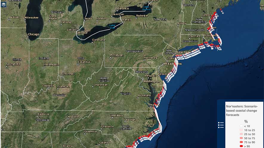
We’ve all seen that storm tracks, for instance, have improved substantially over the years. Because of this variety of storms – such as Hurricanes Andrew, Katrina and Sandy, to name a notable trio -- scientists have more data to base predictions, which can mean a safer coastal population. This year, the United States Geological Survey (USGS) and NOAA have teamed up to provide a new tool for local communities, local forecasters and residents to better understand the likelihood of beach erosion and beach front flooding.
The model provides information on the probabilities of erosion on sandy beaches along the U.S. coast during extreme storm conditions. Storm-induced water levels, due to both surge and waves, are compared to beach and dune elevations to determine the probabilities of collision, overwash, and inundation.
The USGS observations and NOAA wave and storm surge predictions contribute to the coastal change forecast. During an active storm, the USGS’s Coastal Change Hazards Portal makes information easily accessible to the public beginning approximately 36 hours before landfall.
"A really exciting aspect of these forecasts is that several federal agencies are working together, combining their individual expertise, to provide useful tools to the public about coastal erosion," said Hilary Stockdon, Ph.D., with USGS’s St. Petersburg Coastal & Marine Science Center.
An operational version of coastal change forecast model, which is being developed by USGS with the National Weather Service, will make continuous predictions at a relatively small scale of approximately two-tenths of a mile. It can make predictions in all kinds of weather. In the works is field testing by the USGS and U.S. Army Corps of Engineers to study the accuracy of the hourly water level predictions.
Better information does not change the intensity of a storm, but it does give us the ability to better protect ourselves, our families and our communities.
For more information, click here.