By: Ann Windnagel, National Snow and Ice Data Center and Jackie Richter-Menge, Cold Regions Research and Engineering Laboratory
The Arctic is a harsh environment for performing scientific research and there remain significant logistical challenges when it comes to sampling the Arctic Ocean. Satellites have helped to increase our understanding of this variable region of the Earth by providing surface measurements and sea ice extents. However, what about measurements under the sea ice? How can we synoptically collect data about Arctic Ocean bathymetry, sea ice draft, hydrography, and water chemistry? This is where U.S. Navy (USN) nuclear submarines come into play. They offer a unique observational platform because, unlike surface ships, they can operate and take measurements regardless of sea ice cover, weather conditions, and time of year.
With the end of the Cold War, the U.S. submarine fleet suddenly found itself with fewer operational tasks. A quick thinking retired U.S. Navy Captain, George Newton, saw the possibilities immediately. Would it be possible to use these submarines to collect scientific data? Newton thought so, and worked tirelessly to bring together a unique collaboration between military and civilian communities. In 1993, his hard work paid off when the first feasibility test of this idea came to reality as five civilian scientists joined the crew of the USS Pargo for 19 days to utilize this unique platform to gather data about the Arctic Ocean. The test was a success, and the Submarine Arctic Science Program (SCICEX) was launched.
The USN, the Office of Naval Research (ONR), the National Science Foundation (NSF), the National Oceanic and Atmospheric Administration (NOAA), and the U.S. Geological Survey (USGS) signed an agreement to facilitate five more such dedicated missions between 1995 and 1999. During this time, the submarines were modified with temporary alterations of scientific instruments including downward looking sonars to collect bathymetric data and modified valves in the torpedo room for collecting through-hull water samples. However, many of the submarine systems designed for safety could also be used to gather data for scientific studies. For instance, the upward looking sonar provide measurements of sea ice draft, and sail-mounted sensors routinely collect information on water conductivity and temperature.
Beginning with the proof-of-concept mission in 1993, the SCICEX program has been collecting unique data on Arctic Ocean bathymetry; sea ice draft; ocean nutrients; and ocean hydrography in the form of conductivity, temperature, and density (CTD) ever since.
Bathymetry is measured using the submarine's fathometer. SCICEX data contributed to the International Bathymetric Chart of the Arctic Ocean (IBCAO) and led to first-order changes in the mapped positions and depths of major bathymetric features. Knowledge of seafloor topographic features is important for studies of Arctic Ocean circulation, seafloor volcanism, and hydrothermal circulation, and has informed scientific ocean drilling. The SCICEX dedicated science missions systematically mapped portions of several major topographic provinces—Gakkel Ridge, Lomonosov Ridge, and Chukchi Borderland—that have been inaccessible to icebreakers because of perennial sea-ice cover (Edwards and Coakley, 2003).
Ice draft measurements are collected using the submarine's upward looking sonar. By comparing ice draft data collected by SCICEX with previously published data, scientists established that sea ice thinned significantly within the areas where data were collected between 1958 and 1976 and in the 1990s (Rothrock et al., 2008).
Ocean nutrient data are acquired using through-hull water sampling. These data show that the rate of carbon dioxide (CO2) uptake by the Arctic Ocean is twice the average for the global ocean, leading to acidification of the Arctic Ocean (SCICEX Science Advisory Committee, 2010). Estimates of chlorophyll and oxygen reflect the response of Arctic productivity to decreased sea ice extent during summer. SCICEX observations also contribute to a better understanding of freshwater flows, the determination of biochemical conditions such as the levels of nutrients and organic matter at the end of winter, and detection and quantification of the exchange of water between the peripheral shelves and the deep basins.
SCICEX has collected hundreds of measurements by CTD instruments mounted on the sail of the submarine or cast when the submarine surfaced, and from expendable CTDs (XCTDs) launched while the submarine is at depth. Hydrographic data provide definitive, synoptic evidence of upper ocean circulation pathways, and evidence of warming and penetration of Atlantic water as it propagates along basin peripheries and ridges. As the SCICEX data archive has grown, it has played a greater role in climate and modeling studies to validate model results of temperature and salinity distributions. These data have been used to validate numerical model results of temperature and salinity distributions (Karcher et al, 2003), and to evaluate the dynamical implications of mixing parameterization in Arctic regional models (Zhang and Steele, 2007).
In 1998, due in part to a drastic reduction in the size of the nuclear submarine fleet, the Navy announced that they would no longer facilitate the dedicated scientific missions following the scheduled 1999 cruise. Rather than let the program die out, the Navy worked with research funders and the scientific community to come up with a new "bag of tricks" for a modified approach that has been employed since with support from the USN, ONR, and NSF (SCICEX SAC, 2010).
In the new phase of SCICEX, time is set aside for Navy personnel, instead of civilian scientists, to collect unclassified scientific data during otherwise classified submarine exercises. These Science Accommodation Missions (SAMs), as they have been named, are facilitated by the Navy's Arctic Submarine Laboratory.
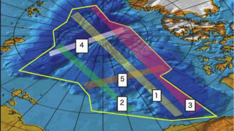
Data collection during a SCICEX SAM is restricted to a certain area of the Arctic Ocean that the Navy has approved for declassification and release of data. As part of the modified approach, scientists have created recommended corridors for data acquisition within this approved area (see figure). As of 2014, there have been 13 missions, 6 of which were dedicated and 7 of which were SAMs. More SAMs are in plans for the future. In 2009, the National Snow and Ice Data Center (NSIDC) became the SCICEX data manager and host of the SCICEX website, providing a comprehensive archive and information hub for the program. Much of the data from the historic dedicated missions are available, while processing of some of the newest SAM data is ongoing. On the website, you can register for data announcements so that you are notified when new data are released.
Today, SCICEX and its bag of tricks continue to flourish with SCICEX data available from 1999 through 2014 via the SCICEX website and more to come in 2016.
To read the original article, visit www.arcus.org/witness-the-arctic/2015/2/article/23163.
