Advances in technology are enabling a new perspective on the critically endangered North Atlantic right whale.
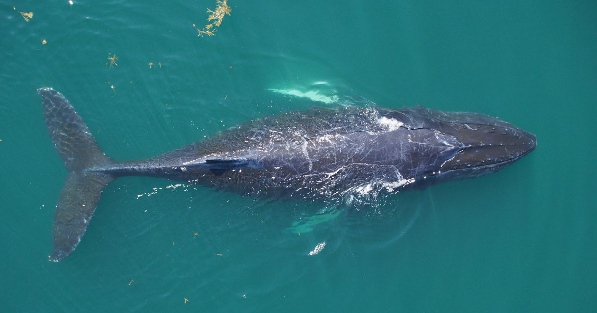
Averaging 13-16m in length and weighing anywhere from 40 -70 tonnes fully grown, North Atlantic right whales are distinguished from other whales – and from each other – by their callosities. These white, rough, keratinised patches of skin, which play host to whole colonies of whale lice, develop from a foetal stage in a pattern on each whale's head that is utterly unique, aiding in identifying individuals.
Identifying individual whales is crucial because fewer than 400 of them are left alive, making the North Atlantic right whale one of the most endangered marine mammals in the world. Hunting of right whales was banned globally in 1937, by which time the population had been decimated by hundreds of years of exploitation. Although humankind has stopped hunting these giants, we continue to constitute the greatest threat to their survival: vessel strikes and entanglement in fishing gear are the leading causes of North Atlantic right whale death. Add to that the potential effects of climate change on their plankton prey and the influence of increased ocean noise on whale communication, and you have a whale of a problem.
It’s this problem that Gina Lonati, a PhD student in the Department of Biological Sciences at the University of New Brunswick’s Saint John campus, is working fervently to address. “Management efforts often focus on population-level health, for example, how many North Atlantic right whales are born or die each year. But methods for gauging the current health of individual whales are limited,” says Lonati. “When the objective of having individual health metrics is to assist with whale conservation programmes, time is against us.”
The drone ranger
Lonati’s journey to try and address this problem began with a conversation with a colleague, Dr Michael Moore from the Biology Department at Woods Hole Oceanographic Institution, who has been grappling with the question of monitoring whale health for years. They started to bounce around the idea of using drone-mounted thermal imaging devices to record the body temperature of whales. “This presented a really exciting research opportunity,” explains Lonati, “because you can collect a lot of data using a drone, much more than from a vessel or plane, and at a much higher resolution, as you can get closer to the whale than you would using a plane.”
Lonati’s methodology involves looking for whales, then hovering the university’s dual-gimbal DJI Matrice 210 V2 drone over a whale when it surfaces, capturing high-resolution images using an RGB camera at 20m above the ocean surface, then descending to 10m to capture a reading of the whale’s internal body temperature via its blowhole using an infrared camera. It is worth noting that drones have been deployed by researchers before to gather information about whales. They're commonly used to collect mucous and microbiome samples from the clouds of vapour exhaled through blowholes – but this is perhaps the first time they're being used to estimate internal temperature. It’s also arguably less gross than retrieving a drone covered in whale mucous.
Lonati plans to gather simultaneous RGB and infrared imagery to start to work out if changes in the blowhole temperature are related to changes in body condition. "For example, is a really skinny whale warmer or colder than a fat whale? How does variation in the thickness of blubber relate to overall whale health? And what does that say about the health of the individual vs that of the population?”
The LiDAR effect
Of course, obtaining accurate and comparable readings requires consistency. Lonati needs to know the exact altitude of the drone when taking the infrared blowhole reading to account for the effects of altitude, humidity, and other environmental factors on the accuracy of temperature estimates. "Unfortunately, I found that the existing drone barometer is not accurate enough," says Lonati. Fortunately, a colleague who’d used it on a similar application recommended the LightWare SF11/C LiDAR to her.
LiDAR is the nifty acronym for “light detection and ranging”. This technology pulses lasers of varying wavelengths at objects and landscapes, measuring the time it takes for the light to bounce back to measure their distance from the LiDAR sensor. It can be used to build highly detailed data point clouds. In the case of Lonati’s project, it offers the advantage of measuring a consistent altitude unaffected by changes in swell or humidity because LightWare’s LiDARs are effective in most weather conditions, even direct sunlight. They are even effective at night as LiDAR is its own light source.
Using LightWare’s SF11/C also offers the advantage of building what feels like a partnership for Lonati. "When you're relying heavily on a piece of equipment, especially electronics, it's great to have a consistent person you can ask questions. The LightWare team understands our project and is there to support us; we’ve built a real rapport.”
Hopefully, through a combination of hard work, technology, and this sort of rapport, Lonati’s research can aid in turning the tide for these critically endangered giants.