
There’s no question that technology has changed every facet of modern life. The corporate world and the health care industry are examples of fields that were quick to capitalize on the power of technology, becoming more efficient. However, until relatively recently the conservation movement lagged far behind in harnessing the power of technology and innovation.
This summer, the Chesapeake Conservancy spearheaded and partnered with the University of Vermont, and WorldView Solutions, Inc. to complete the Chesapeake High-Resolution Land Cover Project, one of the largest, high-resolution land cover datasets for the nation. For 18 months our team of conservation entrepreneurs worked to produce 1 meter by 1 meter resolution land cover data for the entire 64,000 square mile Chesapeake Bay watershed.
Think of this innovative technology as an MRI for the landscape, the results of which will be harnessed, focused, and deployed to practice precision conservation, helping to make the struggling Chesapeake Bay healthier. The datasets are open data and will provide the foundation for all organizations, large and small to work more effectively. This past fall, the project was cited in a White House report, and has been mentioned as model to be replicated nationwide.
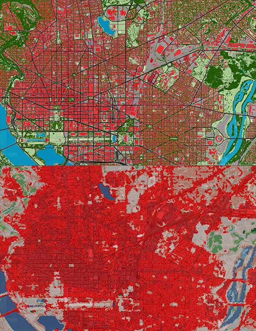
At one-meter resolution, the new land cover data (top) has 900x the amount of detail as compared to the 30-meter resolution National Land Cover Dataset (bottom). This upgrade is a giant step forward for the Chesapeake Bay Program, whose modelers will use the new data to increase the accuracy and precision with which they estimate pollution loads to the Bay. Image courtesy of the Chesapeake Conservancy.
“The power of data behind the Chesapeake Bay High-resolution Land Cover Project cannot be overstated. This is a technological snapshot, the likes of which we’ve never had before, of exactly how the land is being used across the entire watershed. Now restoration and conservation decisions can be made that more closely and accurately reflect real-world conditions,” said Nick DiPasquale, Director, Chesapeake Bay Program.
Leveraging technology to make precision conservation possible for all
Regulations around the Chesapeake Bay’s water quality underlie most restoration work that happens in the watershed. An example of this plays out at the state and local government level. Using restoration and conservation activities, state, county, and municipal governments are working to meet reduction targets for their pollution loads to the estuary and its tributaries. In 2017, progress in these reductions will be reevaluated, as the Environmental Protection Agency (EPA) updates its pollution models that generate the Chesapeake Bay's Total Maximum Daily Load (TDML) limits. A primary goal of the update is to engage counties in the process, and to provide them with information that they can use to plan goals and take actions toward achieving them.
To prepare, the Chesapeake Bay Program (CBP)--a regional partnership of EPA as well as other federal and state agencies, local governments, nonprofit organizations, and academic institutions that leads and directs Bay restoration efforts--pushed for an improvement to their data about the Bay watershed landscape. Here’s where the Chesapeake Conservancy enters the picture. The Chesapeake Conservancy initiated work in June 2015 to create a land cover classification that would provide 900 times the amount of information as the existing dataset.
“This project is ground-breaking in many ways,” Chesapeake Conservancy Director of Conservation Technology Jeffrey Allenby said. “This is one of the country’s largest high resolution land cover datasets. It covers about more than 100,000 square miles and will be free to download for anyone, anywhere. It is really exciting to be at the forefront of a revolution in the way the landscape is modeled, managed, managed and restored.”
The dataset is providing partner organizations the power to practice precision conservation – the right practices, the right skills, at the right place and the right time -- by making effective and impactful decisions about where to target their efforts. It has allowed the CIC to leverage technology not only to identify and prioritize high priority restoration and conservation areas, but also to support partners throughout the watershed in saving time as well as money in implementing projects such as Best Management Practices.
What is Land Cover Data?
Land cover data is categorical information about the natural and human-made features that exist on the landscape, such as buildings, tree canopy, and water. Datasets differ in the geographic areas that they represent, in their spatial resolution, and the number of landscape feature types that they describe. Across the board, they are expensive to make; expert staff, computers, and software are required for production. Without accurate and precise data, however, it is often difficult to set realistic, rigorous pollution targets. Through the Chesapeake High-Resolution Land Cover Project, a dramatic improvement has been made to the resolution of the existing Bay-wide data, allowing the Chesapeake Bay Program and their partners to make decisions that more closely and accurately reflect real-world conditions.
Places like the Gulf of Mexico, where the landscape is rapidly changing, is home to a diverse population of species that are especially vulnerable to these changes, could benefit from a more accurate high-resolution dataset similar to the Chesapeake’s. Such data can help document sea level rise, damage to habitat and infrastructure, and prioritize conservation efforts of places that would add to climate change resiliency in the region.
Examples
This perspective of pushing better, more efficient outcomes also fuels the desire to create easily accessible, creative solutions for partners. Chesapeake Conservancy’s team is building web applications around the land cover and other high-resolution data, such as maps of stream networks, that customize outputs from commercial GIS and remote-sensing software packages.
One such application helps George Washington’s Mt. Vernon Estate maintain a natural “viewshed” across the Potomac River. Viewsheds indicate what landscape features can be seen from a certain vantage point. The Chesapeake Conservancy’s tool enables staff to click on a parcel boundary or draw a building footprint, put in the proposed height of a new building, and see what its visual impact would be on a visitor’s experience, looking out from Mt. Vernon into the surrounding hills.
The team has built other tools working with small land trusts that have no internal GIS capacity. The “Conservation Toolbox” is a prime example of this. It is a web application that characterizes properties and assesses how well they meet certain conservation and restoration criteria. Users can view ecological and cultural data, perform simple landscape analyses, and export their work as a report.
“On the conservation side, we are trying to identify those naturally high-functioning landscapes, such as forest and wetland complexes, that are providing water-quality benefits, habitat connectivity and often climate resilience,” Allenby said.
Yet another such example includes the development of a series of Web-based tools to help the District of Columbia’s Urban Forestry Administration decide where to plant trees on public lands by analyzing such elements as areas where surface water accumulates. Strategic tree plantings can help to reduce the volume and velocity of rain.
In suburban areas, the Chesapeake Conservancy is also is working with some counties to identify opportunities for stormwater retrofits--projects that are installed on existing infrastructure--to reduce the amount of stormwater entering storm drains or getting into creeks. This will help counties to achieve TMDL pollution reduction goals.
“We provide the tools that enable a better understanding of how the landscape is functioning and then prioritizing projects in the places where it makes the most sense to maximize the impact to society at large, while minimizing the costs,” Allenby said.
Allenby believes that development and application of high resolution land cover and tools to other areas of the country like the Gulf, an area that constantly battles the effects of climate change, will be groundbreaking where money and time is limited and stretched thinly. With high-resolution data and customized, easy-to-use web applications, stakeholders could better inform policy- and decision-making efforts.
The Chesapeake Conservancy's mission is to strengthen the connection between people and the watershed, conserve the landscapes and special places that sustain the Chesapeake's unique natural and cultural resources, and restore landscapes, rivers, and habitats in the Chesapeake Bay region. For more information, click here.
By: Margaret Markham, Geospatial Analyst, Chesapeake Conservancy