Getting ocean data has long been a goal of the National Weather Service, which can use real-time offshore information to validate and improve marine forecasts.
NOAA oceanographers need similar data to ground-truth ocean circulation models. Fishermen need accurate marine forecasts and are interested in getting real-time data about ocean conditions from the bottom to the surface to improve their fishing operations.
The Northeast Fisheries Science Center (NEFSC) is collecting data from a variety of platforms that will benefit all three of these groups. Support for this effort has come from several NOAA groups, including the NEFSC, the Center’s Northeast Cooperative Research Program (NCRP), the National Weather Service (NWS), and the North Atlantic Regional Team (NART), which facilitates collaboration across NOAA in the North Atlantic. NOAA's North Atlantic region includes all or part of twelve states and the District of Columbia.
The Northeast Cooperative Research Program (NCRP) has been working with the region’s commercial fishing industry for years to expand electronic fisheries data collection and provide fine scale information that would benefit the industry as well as oceanographers and scientists interested in real-time analysis. NRCP has a study fleet of 37 vessels, located from North Carolina to New Hampshire, and other vessels affiliated with the program that participate in this effort, often through pilot projects.
Two such projects are underway on commercial fishing vessels, the first using a real-time temperature-depth logger to collect ocean bottom temperature data, and the second using a shipboard weather station to collect meteorological.
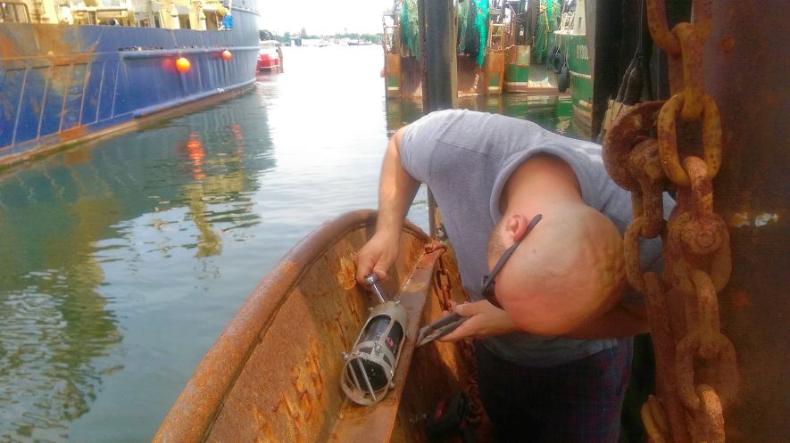
In 2007 the NCRP study fleet began equipping some of its vessels with temperature and depth loggers or sensors mounted on the vessels' trawl doors. The newest sensors, which have been used since 2013 and cost about $2,700 each, are programmed to turn on when the net’s trawl doors reach one meter depth (about 3 feet deep) and turn off at the end of the haul, when the doors are about three meters (roughly 10 feet) from the surface.
Currently there are 25 temperature depth loggers on study fleet boats and 9 on vessels affiliated with other NCRP initiatives. More than three million records have been collected from these instruments and shared with regional oceanographers.
Transmitting that data in real time is now possible. A pilot project began in May 2015 to install $400 transmitters and additional software on the fishing vessels’ wheelhouse computers, made possible by a grant from NOAA’s Advanced Sampling Technology Program, along with additional funds from the NEFSC and NART. Different transmitters and software were tested in order to successfully transmit the temperature-depth data via satellite in real-time back to shore, making the system fully automated.
Twelve vessels, many based in New Bedford, Mass. and Point Judith, RI, are now using the satellite-linked instruments. More than 800 temperature records have been telemetered to shore since May. Once the sensor reaches the surface, it activates a bluetooth connection and sends the data to a computer, the electronic logbook, in the vessel'swheelhouse and then on to a computer in oceanographer Jim Manning’s office back at the NEFSC in Falmouth, Mass. Within seconds, both have these data.
“The vessel captain sees a display of the bottom temperature at depth data on his electronic logbook without having to do anything,” said NCRP's Giovanni Gianesin. “Some study fleet captains find it helpful and can use it to find fish, or to avoid fish they don’t want to catch.”
For oceanographer James Manning, the real-time telemetry of bottom temperature data from fishing boats is a natural progression of a program he began more than 15 years ago with New England lobstermen. Environmental Monitors on Lobster Traps, or eMOLT, collects data using low-cost temperature sensors mounted on lobster traps and GPS surface drifters deployed as part of the program. The sensors cost about $150 each and are reusable. About 70 lobstermen are currently participating in the program, most of them in Maine and Massachusetts.
The data helps ocean circulation modelers better understand processes in the Gulf of Maine, such as how lobster larvae and other planktonic animals and plants, including those that cause harmful algal blooms, drift and settle. This information may also help determine how ocean currents disperse, condense, and transport pollutants, invasive species, and food for whales in portions of the Gulf of Maine.
Although the eMOLT data are not yet available in real-time, Manning hopes to move in that direction with the lobster traps soon. As for GPS surface drifters originally deployed as part of the eMOLT program, hundreds have since been built by students and educational groups around the U.S. and deployed, most with help from the fishing community. Each costs about $500 to make, with many parts available for purchase in a local hardware store.
Approximately 50 New England high schools are building drifters in 2016. The data from the surface drifters are continually updated on Manning’s computer; tracks and other information are available to the public here.
By: Shelley Dawicki, Communication Specialist, NOAA/NEFSC


