The latest technology to be put into the field aboard commercial fishing boats is a stand-alone meteorological package NEFSC oceanographer Jim Manning describes as a “shipboard weather station.”
The weather station includes a barometer to measure atmospheric pressure, anemometer to measure wind speed and direction, and an air temperature gauge. The station also has a built-in computer that factors out the ship’s motion to derive a true wind speed and direction.
The weather station project came about through a fortuitous circumstance. Northeast Atlantic Regional Team (NART) regional coordinator Nicole Bartlett works across the hall from Manning and learned about the work he was doing to telemeter bottom temperatures. The two discussed whether it might be possible to leverage the bottom temperature telemetry project with Northeast Cooperative Research Program (NCRP) to get National Weather Service (NWS) meteorological data from offshore.
The idea: NART would provide some supplemental NEFSC funding to purchase transmitters, and if Manning was successful, NART would approach NWS about purchasing onboard meteorological instrumentation that could be positioned on fishing boats to help NWS validate and improve marine forecasts and warnings.
When the first phase was successful, NART Regional Team Lead Jason Tuell, who is also Director of the Eastern Region for NWS, went to the NWS Observations Portfolio to request the funding. They came through with almost $40,000. And with some help from NEFSC acquisitions lead Kelly Taranto, this transfer enabled the Northeast Cooperative Research Program to acquire the shipboard weather stations.
“We have seen again and again that new collaborations, multi-year demonstration projects like this one, require a little bit of funding and the door swings open. Many of our successful regional team projects have started out this way – with somebody asking a question, and pretty soon we’ve got a coalition of the willing, people who want to collaborate to find solutions,” said Tuell.
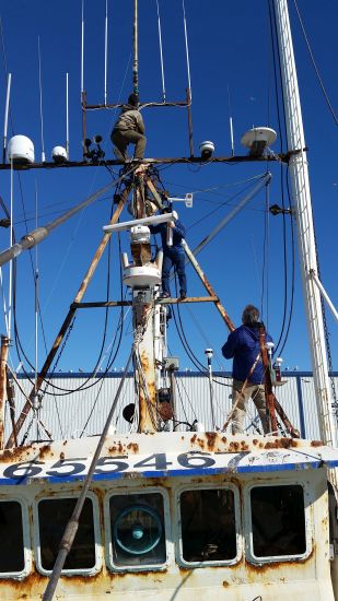
Three of the weather stations, built by a firm in Seattle at a cost of about $10,000 each, arrived at Manning’s office in December 2015 for calibration and testing before being deployed in the field. Since their arrival, Manning has been working with the devices and preparing them for installation on fishing vessels.
To save costs, Manning’s graduate student interns developed the software needed to display data from the weather station in a fishing boat’s wheelhouse so the captain can see it instantly. The same satellite system used to send bottom temperatures will be used to send the weather data to Manning’s computer, and to the National Weather Service, where it can be used to validate marine forecasts.
To see how fishermen would react to having such a device aboard, NCRP staff began talking with study fleet fishermen about the instruments. Long-time Captain Mark Phillips of the F/V Illusion jumped at the chance to be involved. He has been fishing for nearly 50 years, initially out of Long Island, and been a member of the study fleet since 2012. He met with Manning in January during a port call in New Bedford, Mass., and after discussions about where best to position it on a vessel, offered to weld the weather station in place himself on his boat that same day.
“I thought I was just showing him the weather station and seeing what he thought of the idea, but he was so excited the station ended up on his boat within hours,” Manning said of the meeting. Once installed and after some early bugs were worked out, the station has been automatically reporting via satellite every hour for the past two weeks, and Manning reports that the captain is happy with the wheelhouse display.
While on the F/V Illusion that day, Manning caught sight of an old photo of the vessel, and that brought back an interesting connection. Turns out Manning and Phillips had met more than 20 years ago, early in Manning’s career, when one of his first oceanographic moorings on Georges Bank stopped reporting data after months of operation. Manning really wanted the instruments back to see what happened and to retrieve data. As luck would have it, he soon heard from a Mark Phillips, who had recovered them, the same Mark Phillips who is helping him again with this latest project. Manning still has the photos of his family visiting the vessel to pick up the instruments from that mooring. “Small world, for sure,” Manning said.
With one weather station already out in the field, Manning hopes to select two more fishing boats in the next few months and get them equipped with the remaining two weather stations. A number of vessels have expressed interest in participating in the project.
“Many of the fishermen are scientists and they like gadgets,” Manning said. “We want to place them on boats that go offshore for at least a week at a time so we can fill in gaps in the data from offshore waters. The Illusion is a good fit since it covers a lot of ground and is fishing at different places along the Northeast coast.”
By: Shelley Dawicki, Communication Specialist, NOAA/NEFSC