")
Headquartered in Almeda, California, Saildrone offers innovative data solutions in ocean exploration using unique Uncrewed Surface Vehicles (USV). Brian Connon, Vice President of Ocean Mapping, took time out of his busy schedule to speak with ECO Magazine’s editor Haley McQueen about Saildrone’s ‘Mission as a service’ and their data contributions to applied marine science, ocean mapping, climate research, and maritime security.
HM: Can you tell me about yourself and how you came to work at Saildrone?
BC: I completed 28.5 years with the US Navy as an oceanographer and hydrographer, and my first exposure to Saildrone was when I was still on active duty. I was really drawn to the idea of deploying USVs that could go out and execute these very long endurance missions, ultimately keeping people out of harm’s way. Outside of the obvious safety and navigation benefits of USVs, Saildrone’s capabilities to resolve seabed characteristics are important for ocean modeling. The presence of a feature like a seamount impacts the physical graphic of the seabed, but it also influences the chemical and biological aspects of the water column, too. Our goal is to better understand the ocean and make it safe, secure, and sustainable, which makes being part of Saildrone’s overall mission exciting to me.
HM: Speaking of which, perhaps you could speak in a little more detail about Saildrone’s company mission?
BC: In short, Saildrone’s mission is to sustainably explore, map, and monitor the ocean to understand, protect, and preserve our world. The ocean is a major driver of every process on Earth, from weather and climate to carbon to the food chain and more. But there is so much we don’t know about the blue planet because it’s just so vast, the cost of exploration is so high, and it can be very dangerous. Saildrone’s long-term vision is to provide cost-effective data at scale from the most remote areas of the ocean to close those knowledge gaps.
HM: So, just for clarity, Saildrone should be seen as a marine data provider as opposed to a USV Manufacturer?
BC: Many people might see a Saildrone in person or in the press and think, oh, I can go and buy one of these ocean drones and send it out to do what we do… but that is not our business model. Our business model is what we term ‘Mission as a service’. Through this model, we are able to reduce the overall cost and liability of acquiring quality marine data, for a broad range of customers. Essentially, we remove the need to invest in the procurement of a USV or crewed vessel and all the other additional costs associated with training, maintenance, and operations. I guess you could say it’s like obtaining data from a satellite—you aren’t buying the satellite but rather the data it provides.
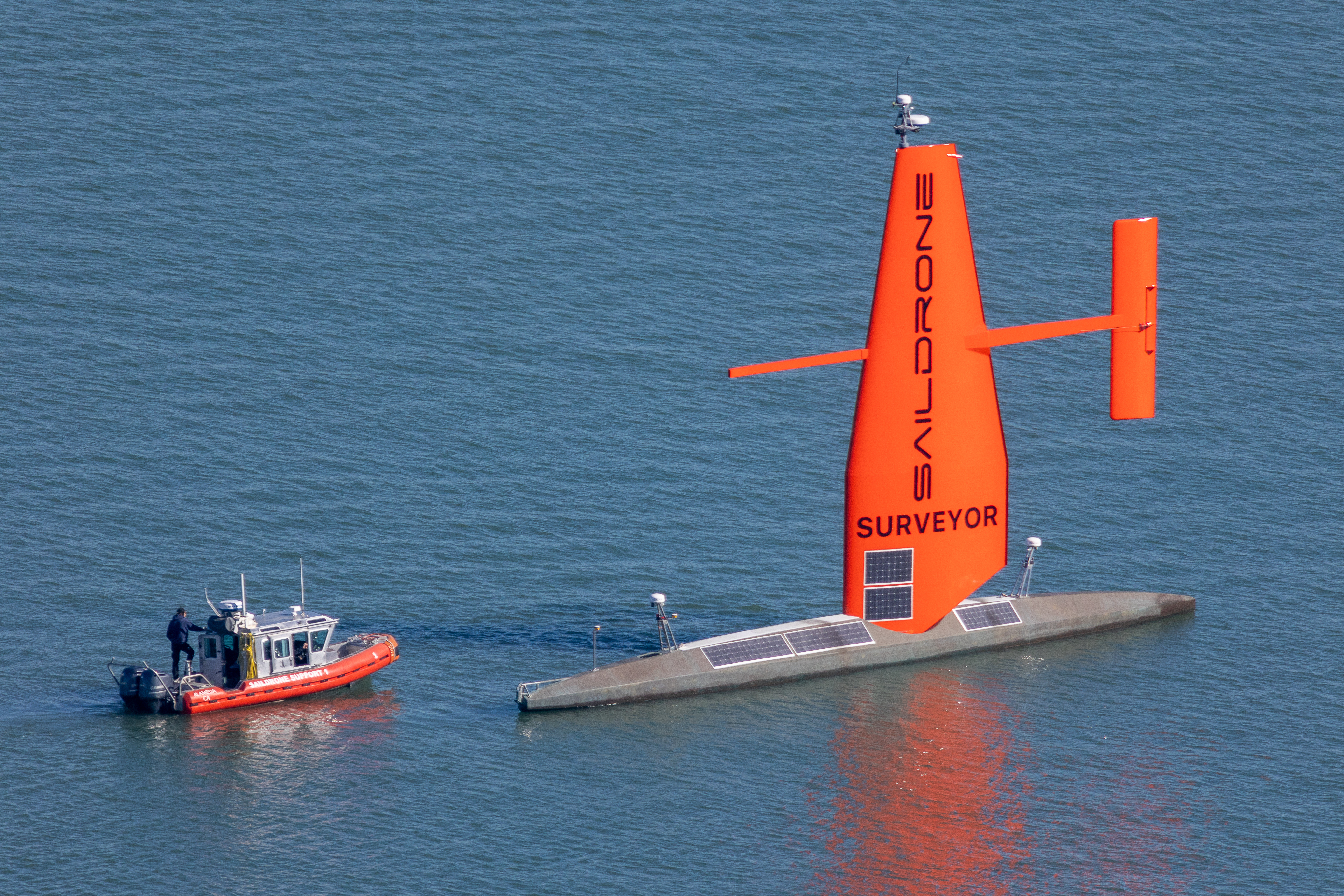
Saildrone's Surveyor—a 65-foot long USV—has a customizable profiling winch capable of reaching up to 450 m depth. (Image credit: Saildrone)
HM: What kinds of marine science applications does Saildrone have?
BC: Saildrone is unique in its ability to be modified and customizable, and because of this, we fit into many areas of marine science. For example, a unique mission for us is a recurring project with NOAA using fisheries sonars to estimate the fish stock in certain areas. This mission was also completed during the height of COVID-19 when research vessels were not readily available for mobilization. As a solution, Saildrone conducted the acoustic fisheries survey, and the data from the mission were used that year to regulate and protect Alaska Pollack fish stocks.
HM: Where does Saildrone provide the most value and advantage?
BC: Compared to traditional means—like ships and buoys—there is less cost and risk involved. Costs, monetary and environmental, are decreased when Saildrone produces the data. Less fuel is used, the risk to personnel is reduced, and the carbon footprint of the USV is significantly less than that of a traditional maritime vessel. Our other big advantage is the ability to scale up. Depending on the size of the vehicle, we can build a Saildrone USV on a weekly, or monthly basis compared to a ship build that will take years. Our ability to scale up quickly means we can meet the problem or answer the question faster.
HM: Outside of general climate and physical ocean measurements, what other water quality sensors are available with Saildrone?
BC: As a customizable platform, Saildrone can integrate a wide range of sensors but I think the most unique sensor onboard is our pCO2 sensor, which was developed by NOAA’s Pacific Marine Environmental Lab. This sensor, paired with a USV, can verify remote ocean pCO2 conditions and allow us to accurately determine where CO2 is being absorbed or outgassed, which is critical information needed for building robust climate models.
HM: Can you talk a little bit about Saildrone’s work with NOAA and the hurricane monitoring that has made many news headlines?
BC: We’ve had two successful hurricane missions in the past two years—in both cases we successfully navigated a USV into a category 4 hurricane. The USVs used were equipped with a shorter, more rugged wing designed for hurricane conditions and can collect around 22 essential ocean climate variables. The main reason for doing this mission is because there is little scientific understanding about why and how hurricanes intensify. This past season we were able to capture the conditions while hurricane Ian was reforming in the Atlantic Ocean after crossing Florida. Data like that will allow for more accurate models and can improve the decisions made in coastal cities for evacuations and preparations.
HM: What are the future priorities for Saildrone’s USV fleet?
BC: As a more economical and sustainable tool for collecting marine data than traditional methods, we see Saildrone USVs expanding in the offshore wind market, conducting large global campaigns for climate modeling and ocean mapping, maritime security, and marine mammal and protected species monitoring.
This feature appeared in Environment, Coastal & Offshore (ECO) Magazine's 2023 Spring edition Sustainable Ocean Exploration, to read more access the magazine here.
