")
On July 25, 2021, a $2.6-million research vessel bearing the name of the late politician Ludy Pudluk left port in St. John’s, making its maiden voyage to the territory of Nunavut, Northern Quebec. Over the next several years, during the ice-free season, the RV Ludy Pudluk will navigate over 4,300 nautical miles in Arctic waters during round trips from insular Newfoundland to four study sites along Nunavut’s coast. The team onboard are part of a new science-Indigenous partnership hoping to utilize Arctic fishery resources to minimize food insecurity in Canada’s Indigenous communities by successfully combining valuable Indigenous knowledge, ocean technology and capacity-building strategies.
For many Inuit communities, the ocean is the main source of food and protein in the region. As fish stocks decline under increasing fishing pressure or relocate due to changing conditions, food insecurity has been increasing across the Inuit Nunangat, or ‘Inuit homeland’. There is hope this can be reversed by expanding subsistence harvesting and, where suitable spawning stock biomass of harvestable species exists, there is interest in small scale commercial development. As a precautionary measure, until it can be established that the productive capacity of a harvested resource can compensate for fishery removals, it is likely commercial development will take the form of supplying natural sources of food to Nunavut’s country food markets.
To contribute to sustainable marine ecosystems in Canada’s Arctic, exploratory fisheries research needs to consider a comprehensive strategy that includes Indigenous traditional ecological knowledge and building capacity to participate in research activities that foster community-based management of renewable resources. As things are today, there are few opportunities for many Indigenous communities to participate in research activities, limiting community partnerships in new emerging fishery initiatives and reducing the ability to extend scientific research.
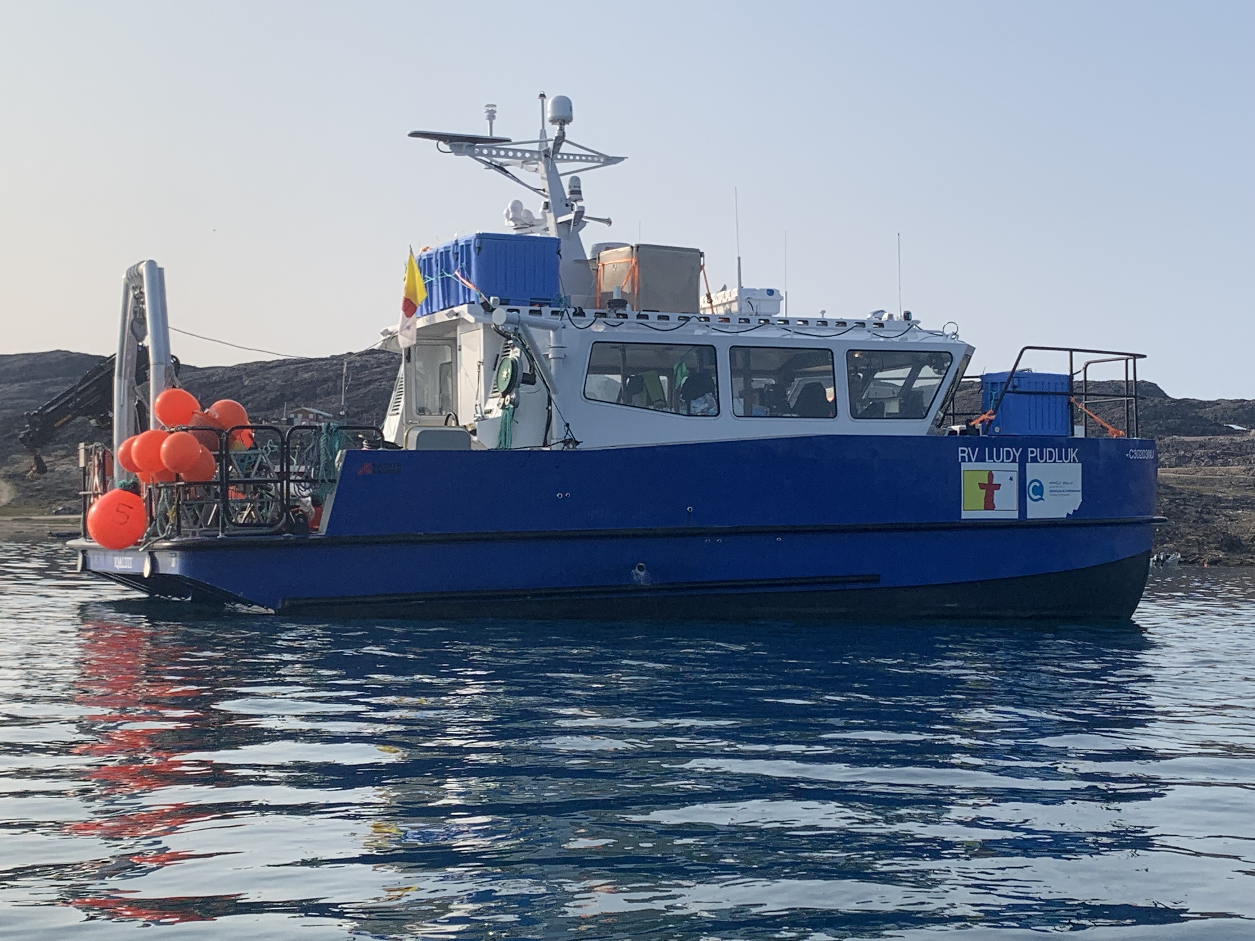
RV Ludy Pudluk at anchor in Nunavut (Image credit: Fisheries and Marine Institute of Memorial University)
During this multiyear study, the newly constructed purpose-built fisheries research vessel owned by the Qikiqtaaluk Corporation, the RV Ludy Pudluk, and Inuit support vessels from the four Qikiqtani Fisheries Alliance communities of Kinngait, Sanikiluaq, Sanirajak, and Igloolik will work together in waters adjacent to each community to explore the fishery potential of benthic marine resources. Sharing of knowledge, training, and capacity building among Inuit community members and researchers from the Marine Institute of Memorial University occurs during data collection associated with ecosystem-based resource assessments with a variety of georeferenced fishing gears, underwater video equipment, seabed and mid-water sampling equipment, and physical oceanographic equipment.
The primary objectives of the science-Indigenous partnerships developed during this project are to carry out collaborative ecosystem-based fisheries resource assessments while promoting information exchange and supporting the development of skills in Indigenous communities. Skills required to not only participate in, but also lead future programs to assess the status of marine resources and contribute science-based information directly related to effective resource management. In addition, by involving graduate students in fisheries and ecosystem research, this research program is training the next generation of scientists who will have a greater understanding of Arctic ecosystems and appreciation of Inuit culture and traditions.
This research and training program is designed to build greater knowledge, self-assurance, and empowerment of Inuit community members with regard to participating in fisheries resource assessments, and management decisions pertaining to renewable marine resources. This is achieved through a community-based participatory research approach that involves Hunter and Trapper Associations sharing traditional knowledge regarding historically abundant species and contribution of two Inuit owned and crewed support vessels from each study community.
Community-provided vessels are outfitted with 12V electric haulers, depth sounders, and GPS provided through the research program. In addition, Inuit from each study community participate in day-to-day fisheries research carried out onboard the RV Ludy Pudluk. During transits to the four Nunavut study communities, the RV Ludy Pudluk also serves as a platform for at-sea training in vessel operations for Inuit from the study communities.
“The time I spent onboard the RV Ludy Pudluk during the transit from Newfoundland to Kinngait and during the fishing gear surveys on boats in my community were a very rewarding learning experience and full of lifelong memories,” Maatiusi Manning, Kinngait, Nunavut.
An important aspect of our benthic resource assessment methodologies is our focus on assessment techniques that minimize impacts to the seabed and organisms that are found there. This is where remote sensing of benthic ecosystems in the form of towed and drop video camera surveys come in. By using video cameras, we can detect where species of interest are concentrated, provide density/biomass estimates, and establish their preferred habitats in a manner that limits impacts. Once concentrations of a species of interest are identified, physical sampling is carried out to collect organisms for life history traits unique to the Arctic.
Further, our research program will be developing and testing the most environmentally friendly fishing gears suitable for use from existing Inuit community vessel infrastructure. Conducting this research in areas where species are known to be concentrated expedites the process and ultimately reduces negative impacts of searching with bottom contact fishing gears. Establishing where concentrations of species of interest occur by remote sensing replaces earlier exploratory methods using only bottom contact fishing gears.
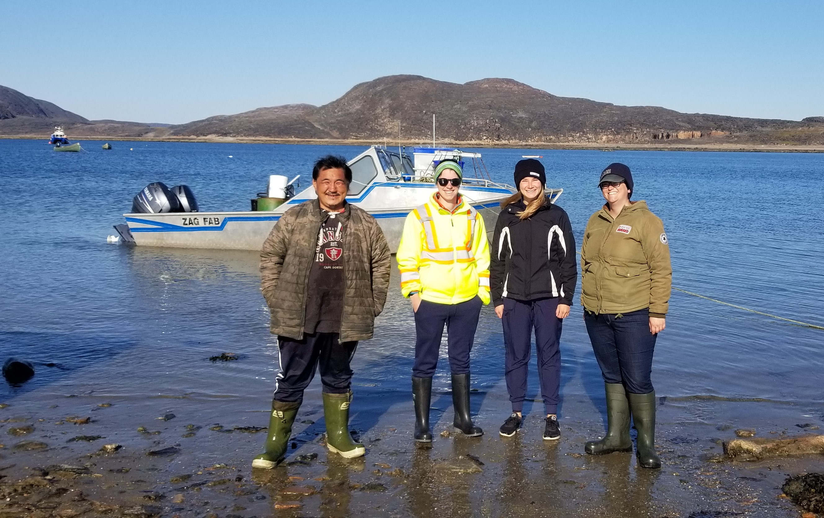
Members of 2021 research team in Kinngait—left to right Takiasuk, Rioghnach Steiner, Samantha Zabudsky, Meghan Donovan. (Image credit: Fisheries and Marine Institute of Memorial University)
Our studies also utilize a second form of remote sensing, multi-beam echo sounder surveys. Multi-beam echo sounder (MBES) surveys are used to map the seabed generating bathymetric maps. The MBES is also used to establish seabed habitat features that help to determine the presence/ absence and densities of benthic species. In the early stages of the process, we can simply use bathymetric maps and georeferenced video observations to establish where a species is concentrated. With continued mapping, we can establish where the available habitat exists for additional verification studies and ultimately predict the total area (km2) of this habitat that exists in a region.
Many of the species we are studying are suspension feeders consuming food particles in the water column (e.g., sea cucumber, Iceland scallop, and soft-shell clam). For this reason, the research program will also utilize 24-hour acoustic Doppler current profiler deployments to establish how bottom currents influence the distribution and density of species of interest. As the process continues, estimates of total area of preferred habitat(s), video analysis of habitat specific densities of a species of interest, and physical sampling of these populations can be used to estimate the standing stock biomass for a region or given area.
Our research program also introduces bottom contact fishing gear surveys as an additional means of engaging Inuit community members in the resource assessment process. These surveys often identify the presence of little-known species that provide new natural sources of protein for community consumption. Use of bottom contact fishing gears also helps to expedite the resource assessment process through a division of tasks and provides organisms for training in the collection of quantitative data. Potting and towed fishing gear surveys complement our remote sensing surveys. When fishing gear surveys conducted from community vessels identify where a species of interest is captured in high numbers, video camera surveys are used to estimate densities and habitat features. Use of bottom contact fishing gears and the quantitative data they provide early in the resource assessment process will be combined with video camera density estimates to establish fishing gear capture efficiency and used to help to make suitable modifications to fishing gears to minimize negative ecosystem impacts.
Community members participate in all aspects of the field research including providing logistical support, identifying fishing and video collection sites based on traditional knowledge, conducting potting and towed fishing gear surveys, towed and drop video camera surveys, and providing input on design and testing of new and innovative fishing gears. Participation of two Inuit crewed vessels from each study community allows the formation of three research teams (i.e., two community vessels and RV Ludy Pudluk) with dedicated tasks and a more comprehensive inshore study.
The success of our studies hinge on Inuit community member participation. Those involved in the project are optimistic that Inuit communities will continue to participate in this program for the next several years given to their longstanding experience dealing with the logistical difficulties of operating vessels in challenging Arctic conditions. But there is also the dire need to improve food security in a region which depends greatly on the ocean for survival.
This feature appeared in Environment, Coastal & Offshore (ECO) Magazine's 2022 Summer edition, to read more access the magazine here.
