")
Understanding the chemistry of the ocean is vital to accurately assess the impact of climate change and ocean acidification on the coastal environments of the Hawaiian Islands.
In search of this critical data, the University of Hawai’i at Mānoa has contracted three Saildrone Explorer uncrewed surface vehicles (USVs) for a six-month mission around Hawai’i Island, Maui, O’ahu, and Kaua’i to evaluate ocean health across the state.
Three Saildrone Explorer USVs were deployed from Honolulu Harbor to understand how ocean acidification is affecting the marine environment around the Hawaiian Islands.(Video credit: Saildrone)
Ocean acidification is a reduction in the ocean’s pH over an extended time period, with its root cause being the uptake of CO2 from the atmosphere—contributing factors including the burning of fossil fuels and over-farming. Some environmental elements directly impacted are organisms that utilize carbonate ions to structure their shells and skeletons, like coral, oysters, clams, sea urchins, and calcareous plankton, putting the entire food web at risk.
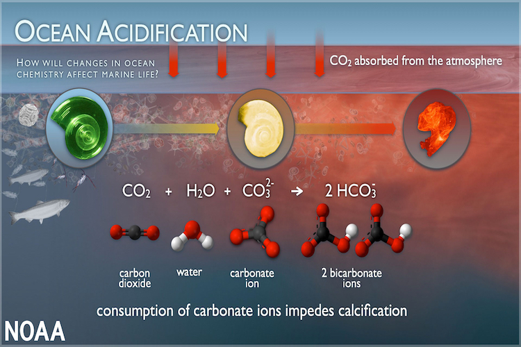 An illustration showing how CO2 uptake from the atmosphere can impede calcification in some ocean organisms. (Image credit: NOAA PMEL Carbon Program)
UH Mānoa has partnered with the National Oceanic and Atmospheric Administration’s Pacific Marine Environmental Lab (NOAA/PMEL) and the University of Washington’s Cooperative Institute for Climate, Ocean, and Ecosystem Studies (CICOES), in an effort funded by the $50 million gift from Dr. Priscilla Chan and Mark Zuckerberg to the Hawai’i Institute of Marine Biology (HIMB).
The islands of Hawai’i are a prime location to collect ocean chemistry data—with 1,052 miles of shoreline and a healthy concern for the regional impact of climate change on ocean life and water quality, there is an immense body of research yet to be compiled on the state’s water make-up. UH Mānoa’s School of Ocean and Earth Science and Technology (SOEST) has extensively researched CO2 in the ocean, and CICOES holds environmental chemistry and ocean carbon as one of its nine core research themes. The samples collected by Saildrone over the course of the mission will provide valuable insights for both groups to determine the chemical health of coastal waters and further understand vulnerability indicators.
The mission will begin off the coast of the Big Island. The USVs will also circumnavigate Maui, O’ahu, and Kaua’i, making strides to create a more complete picture of the carbon water chemistry around these islands. This involves two saildrones zigzagging from the coast to five kilometers offshore, while the third will take a direct path around each island.
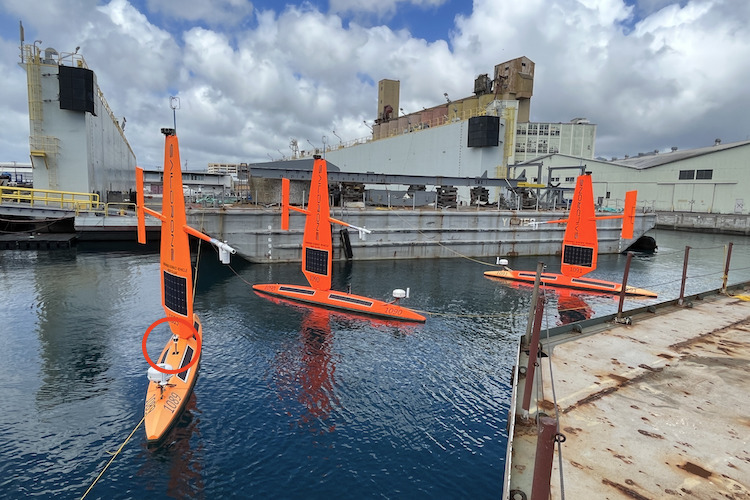 The three Saildrone USVs await deployment in Honolulu Harbor. The vehicles carry the NOAA PMEL ASVCO2 sensor to measure air/sea carbon fluxes (indicated in red). (Image credit: Saildrone)
Saildrone’s ability to take field measurements of pH and carbon dioxide will enable researchers to develop maps of how much fossil fuel emission has accumulated in the areas where the Explorers sampled. By identifying “hot spots” of ocean acidification, the researchers will be able to determine where the water is safe for organisms relying on calcium carbonate.
“These ocean drones will be out sampling continuously for the next six months, providing a thousand times more ocean chemistry measurements in coastal waters than has ever been available,” said Christopher Sabine, UH Mānoa interim vice provost for Research and Scholarship and SOEST oceanography professor.
The Saildrone Explorer is a 23-foot wind and solar-powered USV designed to collect high-resolution ocean data in remote areas of the ocean while creating a zero-carbon footprint. Saildrone USVs are deployed and recovered from any oceanside dock and are designed to fit into a shipping container for transit to any launch site. Once launched, they can make their own way to the area of study, returning to port at the end of the mission. All Saildrone vehicles feature advanced safety protocols, including automated dynamic positioning and piloting based on real-time measurements of GPS location, winds, and currents.
Data collection is only one half of Saildrone’s product. The other half of that is data visualization and delivery. The Saildrone Mission Portal offers customers the ability to track data in near real time and make on-the-fly adjustments to the mission plan based on the intelligence being returned from the vehicles. The data Saildrone is collecting around Hawai’i will increase both the scope and timeliness of the researchers’ understanding of island waters.
“Previously, this type of data was only available via models, it is not real-time data. So the saildrone data will be giving us that real-time information about the water quality,” said Amy Markel, an oceanography Ph.D. student who is working with Sabine on this project. “The saildrones will be measuring different water quality measurements, and this will help tell us a little bit about how our water chemistry is changing with climate change, and with changing ocean conditions in our nearshore environment.”
Saildrone has been operating in Hawaiian waters since 2013 when an early Explorer prototype sailed 2,250 nautical miles from San Francisco to Kaneohe Bay in 34 days. In 2021, the first of Saildrone’s Surveyor class vehicles sailed the same route, arriving in Honolulu in just 28 days. Saildrone regularly deploys or retrieves vehicles operating in the Tropical Pacific from Honolulu, and in 2020, performed a month-long demonstration for the US Coast Guard to show how USVs can be used to combat maritime security challenges like illegal fishing and drug interdiction.
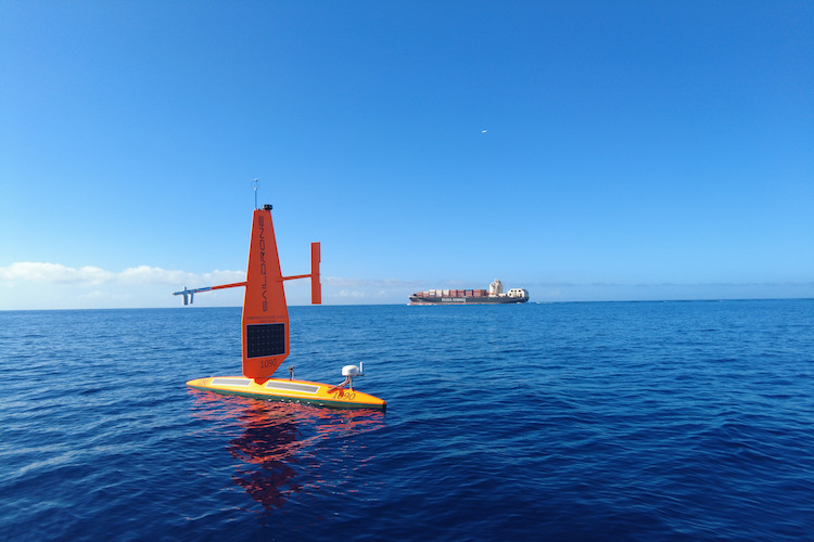 SD 1090 makes its own way to the area of study. (Image credit: Saildrone)
“Saildrone is thrilled to partner with UH Mānoa and CICOES on this important mission to better understand ocean chemistry around the Hawaiian Islands. Ten years after, Saildrone performed the first ‘no-handed’ Pacific crossing, we’re proud to continue our work in Hawai’i, further demonstrating the capabilities of our Explorer-class vehicles to better understand how our oceans are changing,” said Matt Womble, director of ocean data programs.
In addition to the Explorer and the Surveyor, Saildrone also operates the mid-size Voyager, a class of vehicles designed for near-shore ocean and lakebed mapping and maritime security.
