")
The National Ocean Mapping, Exploration, and Characterization (NOMEC) Strategy, led by the interagency NOMEC Council, places ambitious goals upon the United States to map the nation’s coastal, ocean, and Great Lakes waters by 2040 and to explore and characterize priority areas. Mapping activities provide fundamental information to determine priority areas for exploration and characterization; the data collected through these activities as part of the NOMEC strategy inform our understanding of ocean processes, enhance the new blue economy, inform sustainable decision-making, improve national security, and ensure safe navigation.
As of January 2023, only 50% of US coastal, ocean, and Great Lakes waters are adequately mapped. While strides are continuously made to meet NOMEC goals through federal government work, the initiative is most effective when interagency and multisectoral partners work together to promote efficiency and avoid duplication of efforts. Regional mapping campaigns are a critical piece of the NOMEC Implementation Plan, as they are a scaled approach that brings together diverse stakeholder groups to discuss priorities, identify data collection assets and capabilities, determine how to share data, and coordinate efforts to make continuous progress. These campaigns focus the efforts of federal and state agencies and cross-sector partners on priority areas to conduct effective and comprehensive data collection and ensure public data sharing. Where regional campaigns provide project-scale collaboration and coordination capabilities, as well as data management tools, the NOMEC Council can provide national visibility through publications and public engagements to enhance regional capabilities. The NOMEC Council looks to engage, inspire, and invite other interested partners to get involved with Regional Campaigns.
Regional Mapping Campaigns
Regional mapping campaigns predating the establishment of the NOMEC Strategy stemmed from grassroots local efforts and international initiatives. For example, The Nippon Foundation-GEBCO Seabed 2030 global initiative aims to bring together all available bathymetric data to produce the definitive map of the world ocean floor by 2030. Recent campaigns that provided valuable lessons learned for NOMEC activities include the Campaign to Address Pacific monument Science, Technology, and Ocean Needs (CAPSTONE) and the Atlantic Seafloor Partnership for Integrated Research and Exploration (ASPIRE).
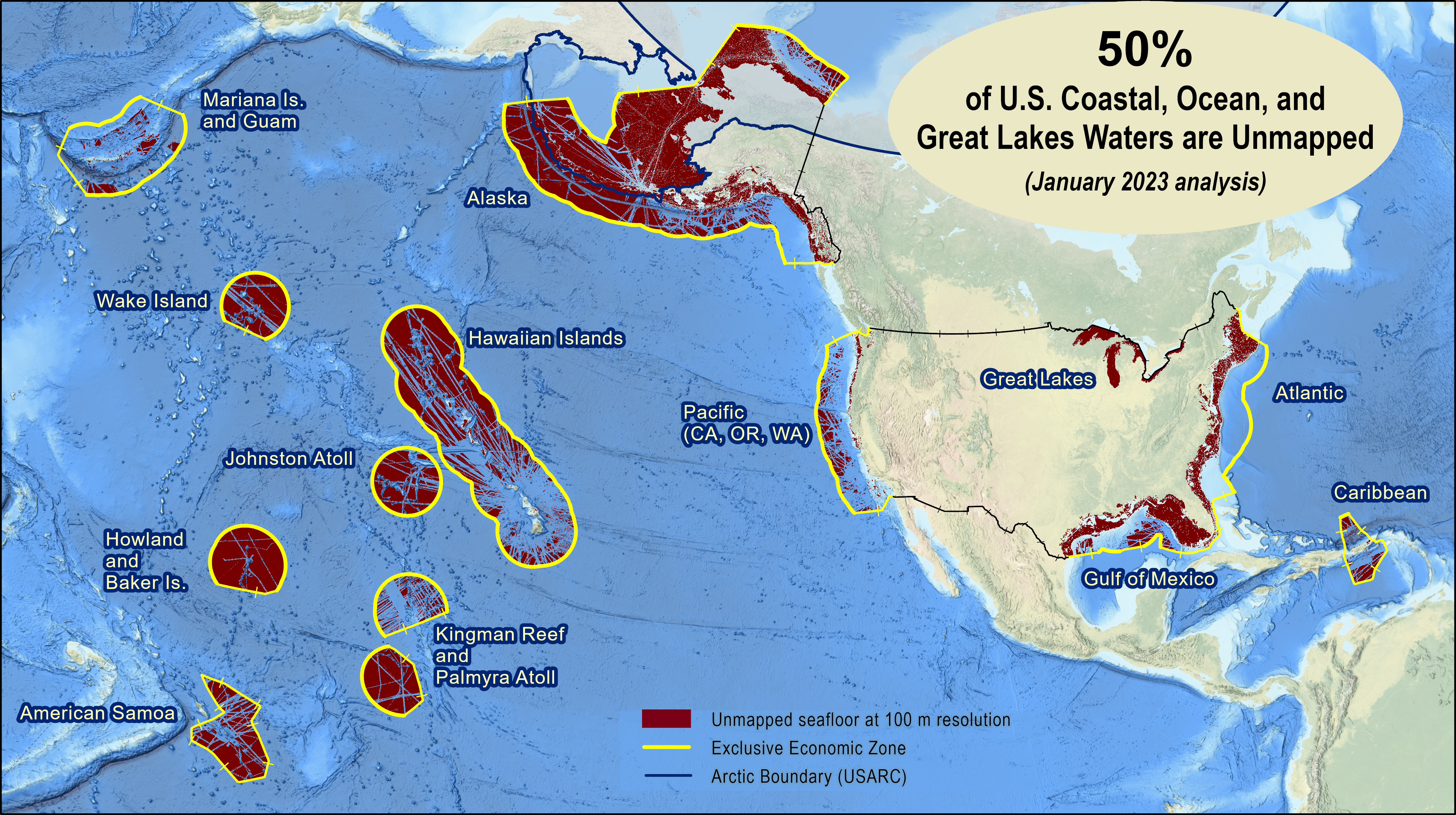
Unmapped US Waters as of January 2023. (Image credit: Meredith Westington, Interagency Workinh Group on Ocean and Coastal Mapping, 2023 Progress Report on Unmapped US Waters)
Born from a need for a greater understanding of the North Atlantic region, ASPIRE demonstrated significant success as a multi-year and multi-partner effort that focused on one region of the seafloor and provided a robust suite of data for management and planning decisions in a heavily trafficked region of the ocean. Under the ASPIRE campaign, many organizations, including the National Oceanic and Atmospheric Administration (NOAA), the US Geological Survey (USGS), and others, conducted expeditions, cruises, and remotely operated vehicle (ROV) dives in a common spatial area, allowing for collaboration and leveraging of platforms across multiple disciplines. The successes of CAPSTONE and ASPIRE were fundamental to the development of the NOMEC strategy and its reliance on partnerships to meet national goals; they are also the continuous inspiration for current and upcoming campaigns. Groups in other regions have developed their own structures for bringing stakeholders together in ways that work for their geography to meet similar goals. Other active campaigns include:
- Expanding Pacific Research and Exploration of Submerged Systems (EXPRESS)—a collaborative effort aimed at gathering data on the deep sea, continental shelf, and slope offshore of California, Oregon, and Washington
- Florida Coastal Mapping Program (FCMaP)—an initiative aiming to facilitate the collection of high-resolution Florida coastal data
- Lakebed 2030—a quickly expanding regional campaign aiming to produce a comprehensive high-density lakebed map of the Great Lakes region by 2030
- Seascape Alaska
Seascape Alaska
Formed in 2021, Seascape Alaska is the first regional mapping, exploration, and characterization campaign built out of the NOMEC Strategy. Campaign partners aim to fully map US waters off of Alaska by following shared values that include accessible data and products, adherence to best practices, collaboration, innovation, and broadly shared plans and progress. Recognizing that Alaskan waters are only 34% mapped to modern standards and predominantly unexplored, the group brings together interested stakeholders, including federal agencies, academia, private sector partners, and Tribes.
This campaign blends ASPIRE and CAPSTONE’s coordinated data acquisition priorities with the Nippon Foundation-GEBCO Seabed 2030 initiative’s focus on consolidated data sharing and the rescue of mapping data that is not broadly accessible. Group activities have included hosting ocean mapping summits to spread awareness of regional activities, as well as data rescue efforts through the campaign’s Data Management Technical Team. In Seascape Alaska’s first year, this sub-team produced the largest gain in publicly available bathymetric data in the state.
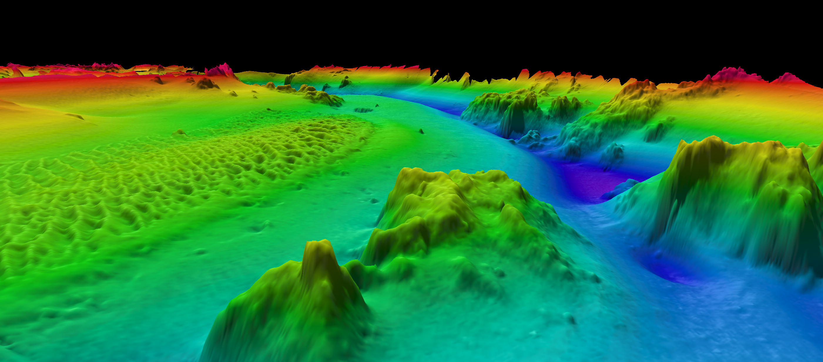
Digital representation of seafloor mapping data. (Image credit: NOAA)
In 2023, Seascape Alaska also had its first campaign branded activities. NOAA Ocean Exploration conducted six expeditions on NOAA Ship Okeanos Explorer, which collected mapping data and conducted ROV dives to further explore and characterize areas of interest around the Aleutian Islands and the Gulf of Alaska. A joint project between NOAA’s Office of Coast Survey (OCS) and USGS collected mapping data to improve NOAA Fisheries’ seabed delineation and USGS’ hazard assessments and forecasting. Other surveys were conducted in Alaska this year by NOAA OCS and its contracting partners.
Building off the successes of Seascape Alaska and the achievements of other campaigns, the NOMEC Council looks forward to creating a regional campaign for the Pacific Islands to continue the work of CAPSTONE. While the E/V Nautilus, sponsored by NOAA through the Ocean Exploration Cooperative Institute, the National Geographic Society, and private donors, works to explore uncharted areas near the Hawaiian Islands, only 53% of the region is adequately mapped with various features of interest left unexplored and uncharacterized.
The NOMEC Council looks forward to promoting the establishment of regional mapping campaigns in other priority areas in addition to the Pacific, such as the Gulf of Mexico. The group is also excited to see existing campaigns continue to bring in new partners and leverage resources in order to make progress toward meeting NOMEC goals. If readers have interests or equities in any of the regions mentioned above, these campaigns are inclusive groups that welcome new members.
To learn more about NOAA’s deep-sea mapping projects, visit: https://www.noaa.gov/ocean-science-and-technology-subcommittee/national-ocean-mapping-exploration-and-characterization-nomec-council
This feature appeared in Environment, Coastal & Offshore (ECO) Magazine's 2023 Deep Dive III special edition Deep-Sea Exploration, to read more access the magazine here.
