 can measure Atlantic Ocean bottom pressure. In 2009, this pattern of above-average (blue) and below-average (red) seafloor pressure revealed a temporary slowing of the deep currents. Photo courtesy of NASA/JPL-Caltech.")
A new paper in the journal Geophysical Research Letters suggests that redistribution of the total ocean mass from ice mass loss and land water storage is causing “the ocean bottom to subside elastically.”
A team of researchers from Delft University and the University of Tasmania used estimates of mass redistribution concluded that past estimates of sea level rise are too conservative and that to increase their accuracy, the effect of ocean bottom deformation should be taken into account, either based on modeled estimates of ocean mass change, or using more direct observations.
The researchers found that from 1993 to 2014, “the resulting globally averaged geocentric sea level change is 8% smaller than the barystatic contribution. Over the altimetry domain, the difference is about 5%, and due to this effect, barystatic sea level rise will be underestimated by more than 0.1 mm/yr.”
And that global difference is slight compared to some regional locations, such as in the Arctic Ocean and the South Pacific.
The problem comes from how we have measured sea level rise in the past. The kind of sea-level change measured by both tidal gauges and satellite altimetry is relative to the Earth’s center of mass, which means that “global mean sea level estimates derived from altimetry will not observe the increase in ocean volume due to ocean bottom subsidence. . .”
What we could instead be measuring, they say, is sea-level change relative to the local ocean floor. After all, the elastic subsidence of the sea-floor is well-defined and the authors say that “the uncertainty of the correction is largely due to uncertainties in the mass redistribution.
As a result, the authors conclude that, “ocean bottom deformation should be considered when regional sea level changes are observed in a geocentric reference frame.”
One source for this information is the twin Gravity Recovery And Climate Experiment (GRACE) satellites, which allow more detailed global and regional estimates of ocean mass changes and comparison with sea level changes.
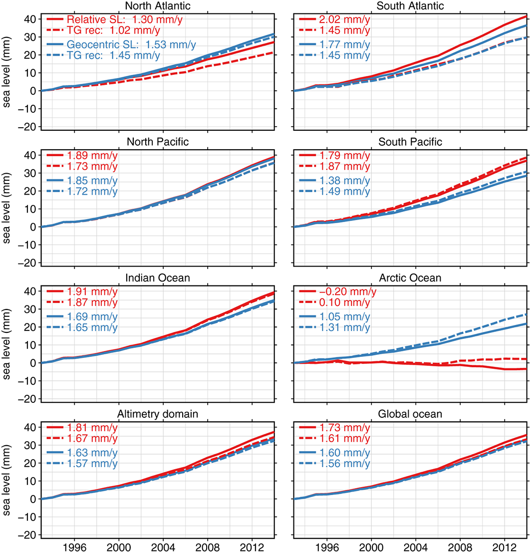 Basin-averaged and global mean effects of present-day mass redistribution on observed relative and geocentric sea level change. The solid line represents the average spatial signal over each region. The dashed line (“TG rec”) represents tide gauge reconstructions based on the virtual station method using the locations of the 627 PSMSL tide gauges. The altimetry domain consists of the global oceans, bounded by ±66∘ latitude. For the virtual station estimate of the altimetry domain, all regions except the Arctic Ocean region are used. Image credit: Frederikse, T., Riva, R. E. M., & King, M. A. (2017)
Original paper: Frederikse, T., Riva, R. E. M., & King, M. A. (2017). Ocean bottom deformation due to present-day mass redistribution and its impact on sea level observations. Geophysical Research Letters, 44. doi.org/10.1002/2017GL075419
By Greg Leatherman, ECO Magazine