; areas to be avoided (darkest pink); locations of greatest fin whale density (red and orange); and lower-density whale areas (yellow, green, and blue). Credit: MarineCadastre.gov")
For more than a decade, people with a big stake in offshore wind-energy plans have visited MarineCadastre.gov to gain instant access to vessel-traffic data that they can filter, map, and share with those on the front lines of siting decisions.
Today, a new tool featuring most U.S. coastal areas—AccessAIS—makes it even easier for users to access these data, as well as ocean data from MarineCadastre.gov on birds, economics, boundaries, federal regulations, and more.
The MarineCadastre.gov AIS database of 30 billion-plus vessel locations has become the go-to resource for maritime planners and ocean geospatial tech experts—but its popularity doesn’t stop there. It attracts ocean industry leaders, experts on natural and built hazards, and protectors of coastal resources and economies. The raw data comes from the U.S. Coast Guard’s Automated Information System (AIS), and the tool was made possible by NOAA and the U.S. Department of the Interior’s Bureau of Ocean Energy Management via MarineCadastre.gov.
Ocean data à la carte
“Because of AccessAIS, what used to take hours or days of data downloading and processing can now be ordered and delivered in minutes,” says Dave Stein, a geographer at NOAA’s Office for Coastal Management and a member of the tool team. “All users need to do to gain access to this huge information resource is to draw a box around their geographic area of interest and select a time range from 2017 to 2022.”
New AIS data are added regularly, and tool uses are growing each month.
Scoping out siting plans
Partners in the Atlantic Coast Port Access Route Study used the data to ensure that emerging renewable energy plans did not conflict with the ship traffic and navigational safety of port users. And fishing vessel owners in southeastern New England used AccessAIS to identify their trawl widths, paths, and turns, so they could communicate potential conflicts with wind turbine placement.
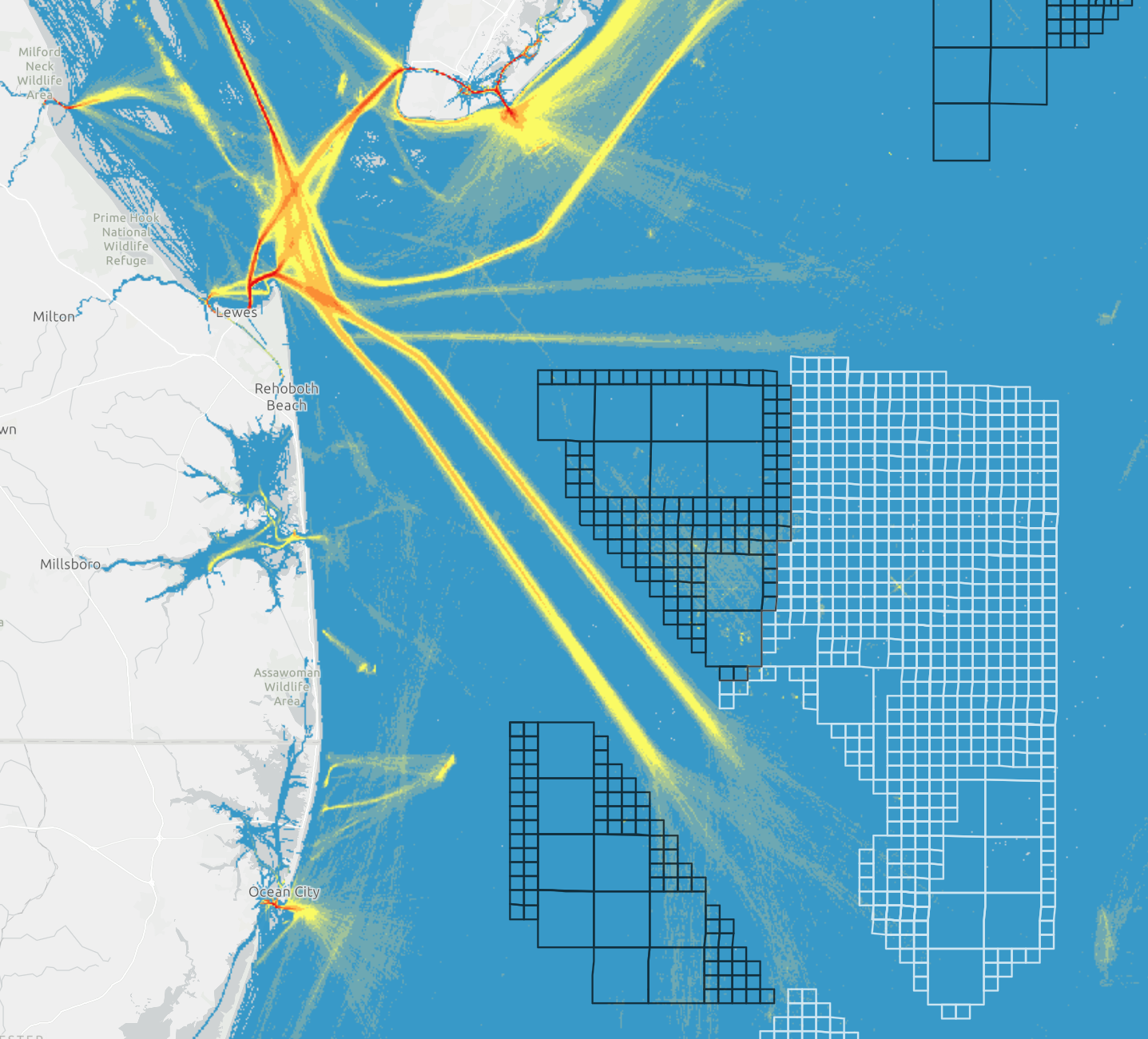 Avoiding conflicts between navigators and offshore wind interests. This Delaware Bay visualization shows wind-energy lease areas (black squares); planning areas (white squares); and two vessel-traffic categories for 2021 (101-250 annual vessels in yellow, and 1,500-plus annual vessels in red). Credit: MarineCadastre.gov
Protecting ecological and economic assets
Partners that include California’s Port of Los Angeles and NOAA’s Office of National Marine Sanctuaries used the data to visualize shipping lane changes that could reduce whale fatalities from ship strikes. The Stellwagen Bank National Marine Sanctuary in Massachusetts researched how noise from large commercial vessels could negatively affect marine mammals. NOAA’s National Centers for Coastal Ocean Science analyzed the potential pluses and minuses of a mussel aquaculture operation along the U.S. northeastern coast. And coastal zone managers in many states use AccessAIS to develop ocean plans that protect ecosystems and local economies.
Sounding out hazard risks
Cruise ship personnel used the data to compare cruise traffic patterns against historical hurricane paths. When a maritime “hit and run” damaged a bridge, users of the tool’s historical data filtered a subset of potential vessels, which helped identify the offending vessel. Users have analyzed the risks of buried submarine cable to area fishing and trawling vessels. And U.S. researchers used the data to model the potential destructiveness of a vessel collision with an offshore liquefied natural gas port facility.