")
Ireland’s national seabed mapping program, INFOMAR (Integrated Mapping for the Sustainable Development of Ireland’s Marine Resource) announces the completion of its “Blue Scale Map Series,” culminating with the release of the stunning Aran Islands Map. In parallel, INFOMAR are also delighted to announce the release of all 18 maps as Gaeilge.
The series, released on a weekly basis and launched on August 11, 2023, has seen the release of 18 bespoke, high resolution bathymetric maps of Irish Coastal waters. Developed by a dedicated team of hydrographers, data processors and cartographers, the maps highlight the topography of the coast in remarkable detail. The launch of the final map of the series also sees the launch of all 18 maps available in Irish, which are available free to download in their own dedicated gallery at www.INFOMAR.ie.
Thomas Furey, INFOMAR Joint Programme Manager at the Marine Institute, emphasizes the dual significance of this release: “The Blue Scale Map Series is a testament on our commitment to both data quality and improving public accessibility of data. The release of all maps as Gaeilge also represents our efforts in promoting linguistic inclusivity and connecting with Gaeltacht communities nationwide.”
In 2006, the INFOMAR program was established and is currently one of the world’s largest and leading seabed mapping programs. Funded by the Department of the Environment, Climate and Communications, INFOMAR is a joint venture by the Geological Survey Ireland and the Marine Institute and aims to map Ireland’s seabed and deliver a comprehensive baseline bathymetry dataset to underpin the future management of Ireland’s marine resource.
Ireland’s coastline is approximately 3,171 km in length and boasts some of the most unique and dynamic marine environments in Europe. The Blue Scale Map Series is the culmination of over a decade of work.
The series’ final map of the Aran Islands, an iconic area of Ireland, that showcases some of Ireland’s most unique and dynamic coastal landscapes.
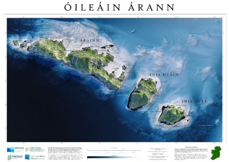 (Image credit: The Marine Institute)
The Aran Islands are a group of three islands at the mouth of Galway Bay, off the west coast of Ireland, with a total area around 46 km2 (18 sq mi). From west to east, the islands are: Inishmore (Árainn) which is the largest; Inishmaan (Inis Meáin), the second largest; and Inisheer (Inis Oírr), the smallest. There are also several islets.
The Islands' geology is mainly karst limestone, related to the Burren in Co Clare (to the east), not the granites of Connemara to the north. Solutional processes have widened and deepened the grykes of the limestone pavement. Pre-existing lines of weakness in the rock (vertical joints) contribute to the formation of extensive fissures separated by clints (flat, pavement-like slabs). The rock karstification facilitates the formation of subterranean drainage.
Speaking about the launch of the map series, Seán Cullen, INFOMAR Joint Programme Manager at Geological Survey Ireland, said: “These maps aim to offer Irish Speakers an opportunity to engage with Marine Science in their native tongue and provide a means of communicating complex scientific data to the broader public.”
Michael Gillooly, Interim CEO, Marine Institute said: “The Gaeltacht constitutes 25% of the overall Irish coastline so I am delighted to see this new series of unique maps now available as Gaeilge.”
INFOMAR invites scientists, educators and the public to explore the new launched Aran Islands map and delve into the dedicated Irish Gallery on its website. This comprehensive resource not only enriches our understanding of Irish coastal landscapes, but also aligns with INFOMAR’s commitment to scientific outreach and data accessibility.
Since 2006, INFOMAR’s seabed mapping efforts have been instrumental in enhancing our understanding of Ireland's underwater landscape.
The Blue Scale Map series offers a new and unique way not only to showcase the mapping effort to date, but also to visualize and communicate complex scientific information to the wider public. As with all INFOMAR data, these high-resolution maps are available for free to download and have huge potential to communicate with local coastal communities and raise awareness on the importance of maintaining the health and integrity of our marine environment.
The maps are available for download here.
Friday 11th August: Cuan na Gaillimhe (Gaillimh) / Galway Bay (Galway)
Friday 18th August: Cean Léime (An Clár) / Loop Head (Clare)
Friday 25th August: Ba Thrá Lí (Chiarraí) / Tralee Bay (Kerry)
Friday 1st September: Uíbh Rathach (Chiarraí) / Iveragh Peninsula (Kerry)
Friday 8th September: Corca Duibhne (Chiarraí) / Dingle Peninsula (Kerry)
Friday 15th September: Bá Bheanntraí (Corcaigh) / Bantry Bay (Cork)
Friday 22nd September: Carn Uí Néid Corcaigh) / Mizen Head (Cork)
Friday 29th September: Loch Trasna (Corcaigh) / Roaringwater Bay (Cork)
Friday 6th October: Na Seacht gCeanna (Corcaigh) / Seven Heads (Cork)
Friday 13th October: Cuan Chorcaí (Corcaigh) / Cork Harbour (Cork)
Friday 20th October: Cuan Eoichaille (Corcaigh/Por Láirge) / Youghal Bay (Cork/Waterford)
Friday 27th October: Cuan Thrá Mhór (Port Láirge) /Tramore Bay (Waterford)
Friday 3rd November: Rinn Duáín (Loch Garman) / Hook Head (Wexford)
Friday 10th November: Ceann an Chairn (Loch Garman) / Carnsore Point (Wexford)
Friday 17th November: Cean Chill Mhaintáin (Cill Mhaintáin) / Wicklow Head (Wicklow)
Friday 24th November: Cuan Bhaile Átha Cliath (Baile Átha Cliath) / Dublin Bay (Dublin)
Friday 1st December: Bá Dhún na nGall (Dún na nGall) / Donegal Bay (Donegal)
Friday 8th December: Oileáin Árainn (Gaillimh) / Aran Islands (Galway)