Louisiana’s coastal basins need help, the state Coastal Protection and Restoration Authority (CPRA) reported at the biennial State of the Coast Conference at the New Orleans Morial Convention Center today (May 31). However, in a panel discussion led by CPRA Operations Chief Ignacio Harrouch, officials also said much has been done in each of the basins, and CPRA has plans to do even more through projects outlined in its 2017 Coastal Master Plan.
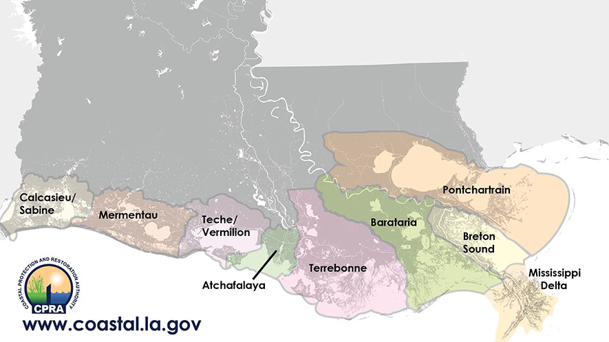
PONTCHARTRAIN BASIN
The 2.75 million-acre Pontchartrain Basin encompasses the area of the Maurepas Swamp, Lake Pontchartrain, Laplace, New Orleans, Slidell, Lake Borgne and out to the Chandeleur Islands. Since 1932 the basin has lost approximately 131,000 acres of wetlands (17%), with more than 608,000 acres of wetlands remaining. The environment ranges from freshwater swamps to brackish and saltwater marshes.
“The degradation of the marshes and swamps is due to a number of factors common along our coast,” said CPRA’s New Orleans Regional Operations Manager John Troutman, “including a lack of fresh water and sediment from the Mississippi River, shoreline erosion, subsidence, sea level rise, and the loss of land formations and the subsequent hydrological impacts.”
Troutman outlined some CPRA projects intended to combat these effects, including the recently completed Bayou Bonfouca Marsh Creation that restored 424 acres of marsh and nourished 500 more on the North Shore of Lake Pontchartrain; projects to restore and save the Orleans Landbridge separating Lake Pontchartrain from Lake Borgne; the Golden Triangle Marsh Creation project to restore 600 acres of marsh near the intersection of the Intracoastal Waterway and the MRGO; the Lake Borgne Marsh Creation Increment One project to restore more than 1,500 acres of marsh near Shell Beach; and the planned River Reintroduction Into Maurepas Swamp to add needed fresh water and nutrients to save an existing environment while it is still in good shape.
BRETON SOUND BASIN
The Breton Basin has experienced a 38% loss of land with more than 105,000 acres disappearing since 1932, the second-highest percentage of land loss in any of our coastal basins, Troutman reported. He said increased salinities have been addressed with freshwater diversions such as the Caernarvon structure, but adding sediment to the basin is of primary importance. CPRA is pursuing a permit to build a controlled, gated structure in the Mississippi River levee above Wills Point in Plaquemines Parish to divert river sediment into the basin. Troutman said the maximum flow would be 35,000 cubic feet per second, but it would be operated at maximum capacity only at certain times according to an operational schedule to be worked out with the Corps of Engineers and other federal agencies seeking to achieve maximum results with the least amount of harm or disruption to the environment, fisheries and commerce. Troutman said CPRA must comply with more than 70 environmental rules and permits. The Corps is in charge of conducting an Environmental Impact Statement. If permitted to go forward, construction would not be completed until 2025 at the earliest.
MISSISSIPPI RIVER BASIN
This region encompasses the vulnerable bird-foot delta of the lower Mississippi River. It has experienced the greatest percentage land loss of any coastal basin, declining from 171,000 acres to just 78,600 acres—a 55% decrease in land mass since 1932. Because of high subsidence rates, projects such as dedicated dredging for marsh creation do not perform well in Master Plan modeling, and no specific projects are included in the 2017 Coastal Master Plan. However, Troutman points out CPRA is highly supportive of other projects that aid the delta basin.
“An excellent example is our partnership agreement with the Corps of Engineers on the Tiger Pass project. The beneficial use of dredged sediment is restoring approximately 5,000 linear feet of historic ridge running along the north side of Spanish Pass, backed with a 500-foot-wide marsh platform. CPRA is putting up $4.5 million of the projected $18.1 million cost of the project.”
Troutman also cited lessons learned about diversions and land building in West Bay where a CWPPRA project intentionally crevassed the levee above Head of Passes. Land was built more expeditiously once the Corps dredged berm-type islands to slow the rate of flow within the bay, allowing sediment to drop out and noticeably accrete. CPRA supports a funding increase and project extension to continue and expand CWPPRA’s Delta Wide Crevasses project, Troutman said.
He also touched on the newest concern: die-off of Roseau Cane, an important marsh plant dominating the delta and helping hold together large portions of the state’s fragile coastline. CPRA is leading the state effort to procure funding for research by Louisiana State University into causes and solutions.
BARATARIA AND TERREBONNE BASINS
Between the Atchafalaya and Mississippi Rivers lies an area of approximately 5,700 square miles, comprised of two basins bisected by Bayou Lafourche: Terrebonne Basin to the west and Barataria Basin to the east. They include a wide range of habitats and landscape features, stretching south to the barrier island complexes influenced by marine processes, with the large shallow bay system behind the islands connecting tidally-influenced marshes.
“The marshes surrounding the bays are typically fragmented saline marshes,” said CPRA Thibodaux Regional Operations Manager Daniel Dearmond. “But as you travel inland those marshes transition to brackish and then intermediate marshes, and finally to freshwater marshes. North of that you get into hardwood swamp habitat, so they’re pretty complex and diverse.”
Adding to the complexity is the mixture of communities and cultures tied to the varying landscapes as well as the numerous economic assets and commercial infrastructure, such as Port Fourchon, the nation’s leading energy port.
“The variety of habitats, fisheries, and commercial infrastructure across such a large area presents us with unique challenges when it comes to implementing projects to restore habitat and reduce storm surge risk,” said Dearmond. “These basins have historically experienced high rates of land loss with some areas rapidly converting to open water. It’s the challenge we face every day.”
These basins have seen the most extensive projects in state restoration history, including dredging and placing more than 67 million cubic yards of sediment from the Mississippi River and offshore sources, and the expenditure of more than $761 million to rebuild our first line of defense, the barrier islands and headlands at the perimeter of the basins, including the reconstruction of East Grand Terre, Bay Joe Wise, Scofield Island, Pelican Island, Shell Island, the Caminada Headland and Elmer’s Island, West Belle Pass, East Island, Trinity Island, Raccoon Island, and Timbalier Island and East Timbalier Island.
An additional $244 million in projects are now in engineering and design to add to the restoration of the basins’ perimeter, Dearmond reported.
ATCHAFALAYA AND TECHE/VERMILION BASINS
These basins are unique among the Louisiana coastal area in being relatively geologically stable, benefiting from the Atchafalaya River, reported Glenn Ledet, Jr., the Assistant Administrator of the CPRA Operations Division.
“However, that doesn’t mean they are safe from evolving conditions,” said Ledet. “Artificial barriers created, or natural barriers removed, alter the hydrologic flow and deposition of sediment. And these basins are not immune to sea level rise and shoreline erosion.”
Ledet highlighted some of CPRA’s projects now in the construction phase, including the Coles Bayou Restoration project to create more than 400 acres of marsh and to install a series of culverts at nine locations to increase the inflow of fresh water and sediment; and improving pump stations and levees protecting Morgan City from Lake End to Justa Street as well as raising the elevation of 2,100 feet of Louisiana Highway 70.
A study was completed to assist project planning for levee districts in the basins. It evaluated levee alignments across Iberia and St. Mary Parishes to reduce potential flooding and examining the possibility of upgrading the river levee system in St. Mary Parish that has proven deficient in protecting the area from tropical and hurricane storm surges.
A longer-range planning effort is also evaluating the benefits of increasing the eastward flow of fresh water from the Atchafalaya River system in the vicinity of the Bayou Boeuf Lock. The goal would be to help increase sustainability and prevent wetland losses of up to 18,000 acres over 50 years.
CALCASIU/SABINE AND MERMENTAU BASINS
All or parts of the parishes of Vermilion, Cameron and Calcasieu make up the vast basins covering the southwest corner of Louisiana. More than 768,000 acres of wetland habitat stretch from the Sabine River bordering Texas to the Intracoastal City area along Freshwater Bayou.
“It is a very watery environment,” said CPRA Lafayette Regional Operations Manager Darrell Pontiff, “and therein could lie the problem if things continue unabated: too much water and not enough land.”
The Mermentau Basin’s primary source of fresh water is the Mermentau River, and includes the large freshwater reservoirs of Grand Lake and White Lake. The Calcasieu/Sabine Basin was historically a freshwater system, fed by the fresh water of the Sabine and Calcasieu rivers.
“Saltwater intrusion up the Calcasieu Ship Channel and into Lake Calcasieu has dramatically changed that freshwater basin into a brackish marsh, and it’s a great one, very productive, people like it,” said Pontiff. “But it won’t stay that way if the salinity continues to increase at the alarming rate we’ve been seeing.”
The Mermentau Basin is fresher, but erosion of the coastal perimeter and resulting saltwater intrusion threatens that area as well, with the eventual possibility of the marsh separating the three big bodies of water—Calcasieu, Grand and White Lakes—dying off and merging the area into one large body of open water, a big step towards the coast retreating many miles inland.
Pontiff spoke of several projects to mitigate the damage. Shoreline protection projects on the coast in Cameron Parish have delivered nearly two million cubic yards of offshore sand to rebuild the beach perimeter in front of vital Highway 27, and more offshore sand was used over 800 acres of the most vulnerable marsh behind that highway at Oyster Bayou. Hundreds of millions of post-BP oil spill money is to be used for salinity control in the Lake Calcasieu Ship Channel, while additional projects for marsh creation freshwater introduction are underway or in engineering and design. Pontiff also highlighted a project just entering the construction phase on the shoreline in front of the Rockefeller Wildlife Refuge.
“Many people think we can just put rocks out there everywhere,” said Pontiff. “But in many places they’re just too heavy and sink too deeply and quickly. But for this project we’re bagging a lighter-weight concrete aggregate that we’ll lay on the shoreline, then cover with the heavier rocks. If this proves to be sustainable, it could possibly be of use in other areas. We’re going to find out.”
