 uses pulses of lasers to record the bathymetry, or underwater topography, on the seafloor at centimeter-scale resolution. Surveys with this sensor suite at a scour field 1,840 meters (6,037 feet) deep on the floor of Monterey Canyon revealed how turbidity currents (green) and tides (blue) affected the structure of the seafloor. (Image credit: Monica Wolfson-Schwehr)")
Deep below Monterey Bay lies one of the largest submarine canyons on the west coast of North America. Monterey Canyon has a topography that rivals the Grand Canyon, but its scale and grandeur remain out of sight beneath the waves.
Repeated efforts at MBARI to map and monitor this submarine canyon have revealed a surprisingly active seabed. Monterey Canyon is a dynamic environment. Frequent landslides tumble through the canyon and affect the community of life that thrives on its rocky walls and sediment-covered floor.
A team of researchers from MBARI, USGS, Durham University, the University of Hull, and Pontificia Universidad Católica de Chile conducted surveys of a site on the floor of Monterey Canyon canyon’s floor with an innovative sensor suite designed by MBARI engineers. Their repeated surveys have provided new insight into the processes that sculpt canyons. The team published their findings in a recent issue of JGR Earth Surface.
“Thanks to advanced MBARI technology, we’ve now mapped parts of Monterey Canyon in remarkable detail. Repeated mapping surveys have given us a valuable new perspective to study the processes that sculpt the canyon. This is vital context for understanding not only life on the ocean floor but also how the underwater infrastructure that we depend on may be vulnerable to underwater landslides,” explained Monica Wolfson-Schwehr, previously a postdoctoral fellow at MBARI and lead author of this study.
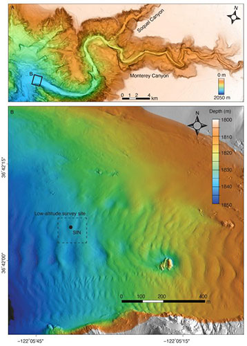 Monterey Canyon (A) is located just offshore of MBARI’s research facilities in Moss Landing, California. MBARI researchers conducted high-resolution, low-altitude surveys in a part of the canyon floor 50 kilometers (31 miles) from the canyon head (B) and deployed the Seafloor Instrument Node (SIN) to monitor environmental conditions, like currents, at the site. Together, these shed new light on processes that sculpt submarine canyons. (Image credit: Monica Wolfson-Schwehr)
From 2015 to 2017, MBARI’s Coordinated Canyon Experiment aimed to monitor the passage of sediment gravity flows—underwater landslides known as turbidity currents—at multiple locations in the canyon simultaneously. Understanding the complex geological processes that shape Monterey Canyon can help us better understand how submarine canyons might be tied to coastal geohazards, like local tsunamis or risks to underwater telecommunications infrastructure.
As part of the Coordinated Canyon Experiment, MBARI researchers deployed a variety of scientific instruments, including the novel Low-Altitude Survey System (LASS), to investigate the ongoing processes that carve Monterey Canyon.
Developed by engineers in MBARI’s Seafloor Mapping Lab, the LASS can visualize the seafloor in remarkable detail. Attached to a remotely operated vehicle (ROV), the LASS combines five-centimeter resolution multibeam (sonar) bathymetry, one-centimeter resolution lidar (laser) bathymetry, and two-millimeter resolution stereo photography.
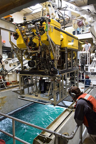 Image 3: By outfitting the remotely operated vehicle (ROV) Doc Ricketts with the innovative Low-Altitude Survey System (LASS), MBARI researchers were able to visualize the floor of the Monterey Canyon in centimeter-scale detail. (Image credit: Dave Caress)
As the ROV moves three meters (10 feet) above the seafloor, lasers, and sonar pulse to the bottom. The sonar records the structure of the underlying seabed, including rocks and mud. The lasers record any three-dimensional object below the ROV, including living animals with soft tissues. High-resolution photographs captured during the survey can then be draped onto the bathymetry data to create a realistic image of the seafloor. These incredibly detailed surveys can quantify the impact of the geological, geochemical, and biological processes that modify the seafloor at fine scales.
The research team conducted several centimeter-scale surveys with the LASS instrument. The study site was approximately 50 kilometers (31 miles) from the head of Monterey Canyon at a depth of approximately 1,840 meters (6,037 feet). They conducted four surveys over an 18-month period. These surveys represent the highest resolution to date in a submarine canyon.
“MBARI’s Low-Altitude Survey System maps seafloor environments at the scale of the animals that live there, making it particularly useful for ecological studies. In this geological project, the lidar bathymetry data revealed changing centimeter-scale textures in the sediment on the floor of Monterey Canyon that would have been undetectable by more traditional methods like ship-based sonar or even the autonomous mapping robots we use to map at one-meter scale,” explained MBARI Principal Engineer Dave Caress. “Even though MBARI scientists and engineers have been exploring Monterey Canyon for more than 25 years, our new technology is constantly revealing surprises.”
Pairing repeated surveys of the canyon floor with water current monitoring and sediment sampling provided researchers with a more complete picture of activity in Monterey Canyon.
As part of the Coordinated Canyon Experiment, the team deployed a Seafloor Instrument Node (SIN) on the floor of Monterey Canyon. Upward-looking acoustic Doppler current profilers on this instrument recorded the currents flowing along the canyon.
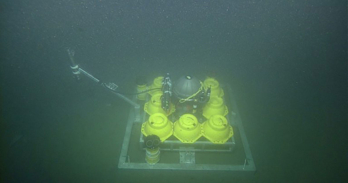 As part of the Coordinated Canyon Experiment, MBARI researchers deployed the Seafloor Instrument Node in the center of the survey area to measure conditions on the floor of Monterey Canyon, 1,840 meters (6,037 feet) deep. (Image credit: MBARI)
Fast-moving turbidity currents carry sediments and organic carbon along submarine canyons. They drape sediment across the canyon floor, infilling bedform troughs and smoothing erosional features. Powerful turbidity currents can also destroy underwater cables, pipelines, and other seafloor infrastructure. Unlike current flows in rivers, turbidity currents are incredibly difficult to study and measure, especially due to their unpredictable nature.
Between 2015 and 2017, sensors on the SIN recorded three turbidity currents with speeds of 0.9 to 3.3 meters per second (two to 7.4 miles per hour). Turbidity currents with similar speeds in the upper Monterey Canyon produced significant and rapid bedform migration. However, the LASS surveys indicated that these three events failed to cause notable changes to the seabed at the canyon floor.
Studying sediment samples from the lower canyon revealed the relatively coarse nature of the seafloor at this location. Coarse sediment suggested that the turbidity currents in the lower canyon lacked the fast, dense layers near the base of the flow that are characteristic of turbidity currents recorded farther up-canyon. The large boulders that underlie the bedforms in the lower part of the canyon may have also accounted for the negligible changes to the seabed that the team observed.
While turbidity currents are powerful and unpredictable events, daily tides also oscillate up and down a submarine canyon.
Sensors on the SIN recorded the daily rhythm of the tides on the canyon floor. The amount of sediment moved by internal tides is too small to be detected by traditional ship-based instruments. The detailed data provided by MBARI’s LASS sensor suite changed that. Now, researchers could finally take accurate measurements of the changes to the structure of the canyon floor due to tidal currents.
The team determined that the ebb and flow of the tides carved the small, meter-sized scours and centimeter-sized textures they observed on the seabed at the canyon’s floor. Previous mapping work in the area missed these features because the resolution—even the meter-scale maps from MBARI’s mapping vehicles—was too coarse.
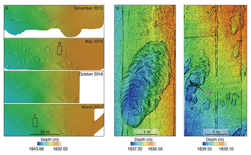 Image 5: Four repeat surveys with MBARI’s LASS sensor suite between November 2015 and April 2017 provided an incredibly detailed view of the changes to the floor of Monterey Canyon. The LASS combines various sensors, including sonar bathymetry at a resolution of five centimeters (two inches) (A) and lidar bathymetry (B and C) at a scale of one centimeter. Lidar data provide richer detail about the seafloor, revealing objects that are too small to be seen by sonar. (Image credit: Monica Wolfson-Schwehr)
This study demonstrated how new mapping technology may eventually bridge the scale gap between modern seafloor surveys and the ancient rock record.
“With sonar, we see the aftermath of large, catastrophic events, but miss the small, minute changes that happen every day,” said Wolfson-Schwehr. “As technology advances and we can map at finer and finer resolutions, we can observe a new level of complexity in the seabed. We don’t realize how much of the picture we’ve been missing.”
“Geology has always been a historical science that looks at seafloor deposits laid down a long time ago. MBARI technology is allowing us to study submarine geomorphology at a scale we haven’t been able to before. Repeated high-resolution surveys are providing a real-time dimension for understanding seafloor changes,” added Charlie Paull, a senior scientist at MBARI and a coauthor of this study.
MBARI’s Seafloor Mapping Lab has used the LASS sensor suite to map a variety of other seafloor features and habitats at centimeter scale, including methane gas seeps, faults, deep-sea coral and sponge communities, octopus nurseries, and hydrothermal vents.
“We can’t understand global change to the ocean floor without quantifying it,” said Paull. “Repeated use of MBARI’s Low-Altitude Survey System allows us to collect unique quantitative data that put into perspective exactly how big these changes are. We now have a new window into how the world operates.”
MBARI is continuing to develop and improve its seafloor mapping capability. Building on the success of the LASS, MBARI is collaborating with 3D at Depth to develop a next-generation underwater lidar system that can be integrated into autonomous platforms and enable further progress in efforts to map the deep ocean floor in the future.