Living in
the Dark
Odysseus ROV Supports Expedition in Search of Deep-sea Corals
Living in the
Dark
Odysseus ROV Supports Expedition in Search of Deep-sea Corals
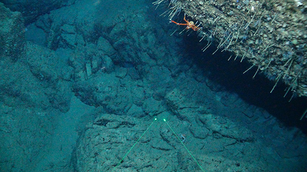
Unmanned technologies like ROVs, autonomously operated vehicles (AUVs), and rovers are used by scientists in many fields to study extreme environments from the deepest parts of the ocean to outer space. On the first leg of the Southeast Deep Coral Initiative (SEDCI) expedition, scientists used the ROV Odysseus operated by Pelagic Research Services, to survey deep-sea coral ecosystems on the West Florida slope aboard NOAA Ship Nancy Foster.
Built specifically for deep-sea research and exploration, ROV Odysseus is capable of diving to depths of 6,000 meters (over 20,000 feet), which is as deep as Mount Denali is tall! ROV Odysseus remains connected to its host ship by an umbilical that contains the ROV power conductors and fiber optic cables, which send back real-time video and other sensor data to the ship.
ROV Odysseus is fitted with a myriad of tools to help pilots navigate the vehicle, such as sonars, altimeters, and depth sensors. For this project, the vehicle was also equipped with various environmental sensors to help onboard scientists understand the physical environment that deep-sea corals inhabit. Continuous environmental data on temperature, salinity, pH, and dissolved oxygen were collected on every dive of the expedition.
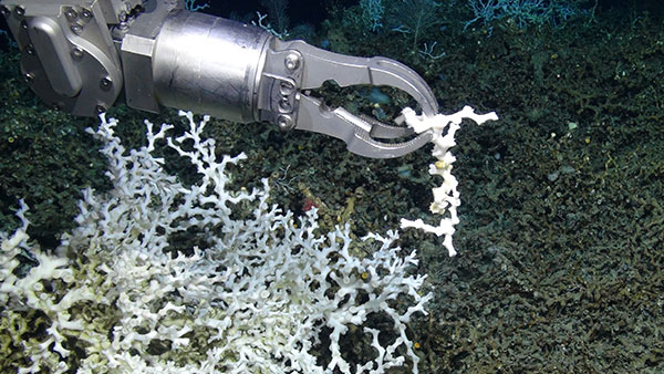
The Odysseus ROV system can also collect scientific samples such as sediment cores, coral specimens, and other samples such as sponges and rocks. To collect samples for this project, Odysseus was equipped with a seven-function manipulator arm, which acts similarly to a human hand. Operated from the control van on the ship, this manipulator arm provides incredible dexterity and strength to collect even the most delicate coral samples.
The ROV is able to sample biological specimens and keep them alive because it has an insulated biobox that holds seawater from the depth at which the animal lives. On this expedition, 14 live specimens of the deep-sea coral Lophelia pertusa were collected, all of which are currently being maintained alive in aquaria to study their reproduction in the laboratory.
ROV Odysseus is also fitted with powerful lights (5,000 lumen) and a high-definition camera, which can take beautiful images of deep-sea corals and other marine life. High-definition video is streamed back to the ship in real time and overlaid with navigational data from both the ship and the ROV. This video is recorded, allowing scientists to revisit each dive once they are back on shore and know exactly where they spotted a particularly impressive coral or other noteworthy event.
Most importantly, the ROV Odysseus is supported by a hard-working team, which includes ship personnel, who navigate the ship to desired dive locations, provide support to launch and deploy the vehicle, and provide mechanical support, as well as the ROV team, who keep the vehicle working well, pilot it on the seafloor, and aid scientists in meeting their objectives. With extensive expertise in ROV operations, electronics, and engineering, the Pelagic Research Services team helps ROV Odysseus, and the scientists who work with it, illuminate the many mysteries of the deep sea.
About the SEDCI Expedition: Leg 1
Supported by NOAA's Deep Sea Coral Research and Technology Program, SEDCI expedition research focuses on management priority areas identified by the Gulf of Mexico Fishery Management Council and the South Atlantic Fishery Management Council.
In addition to ROV surveys and mapping operations, the 2017 SEDCI expedition collected environmental data and water samples on both legs of the expedition. These data and samples were collected using the Nancy Foster’s CTD Niskin bottle carousel and will help characterize the physical environments that deep-sea corals occur in across the Southeast Region. This information is critical to understanding how deep-sea corals might respond to changing environmental conditions in the future.
Complementing its scientific objectives, the 2017 SEDCI expedition also focused on education and outreach. Graduate students from the University of South Florida, Texas A&M University, Florida A&M University, the College of Charleston, and Nelson Mandela University will participate in the expedition. As you can see from the video and photos here, the expedition also included the participation of a professional videographer.
"Many types of samples were collected – images, water, biological, and rocks. A total of 59 water samples were collected for carbonate chemistry."
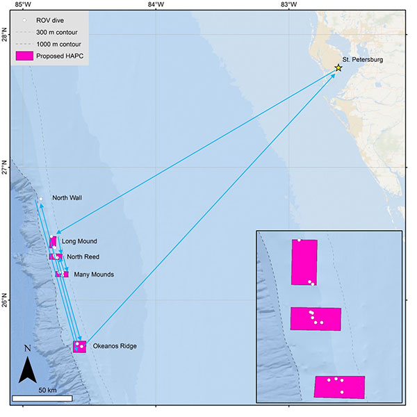
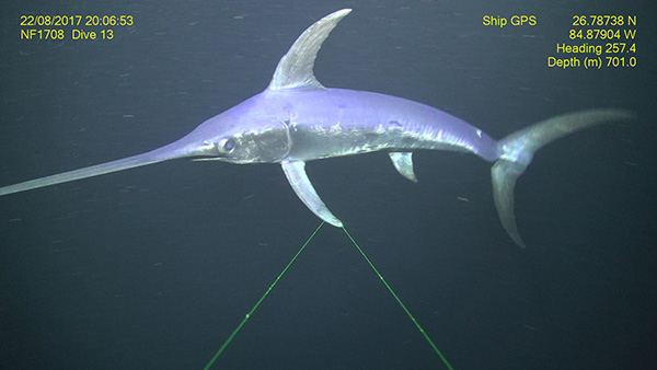
According to Dr. Peter Etnoyer, Chief Scientist for Leg 1 of the SEDCI Expedition, his team, “made 13 successful dives over 10 working days, thanks to good weather. Total bottom time was 51.5 hours. The sea state was calm but surface currents were strong. The team explored four out of five target sites, including Long Mound, North Reed Site, Many Mounds, and Okeanos Ridge. Pulley Ridge was dropped due to weather. A new site was added called ‘Wall in the North,’ where we had an unexpected encounter with a swordfish.”
During the Gulf of Mexico leg, high-resolution seafloor maps were generated for close to 2,300 square meters, including 1,965 square meters that had never been mapped before. That’s equivalent to about 22 football fields! The maps showed a long linear feature in the 200-250 meter depth range that Etnoyer says is a prime target for future exploration.
He adds, “Many types of samples were collected – images, water, biological, and rocks. A total of 59 water samples were collected for carbonate chemistry. The CTD rosette was deployed 17 times in the vicinity of deep coral reefs, mostly to 400-500 meters depth, but as deep as 1,000 meters. The number of biological samples collected was 51. Of those, 14 corals were maintained alive, including a rare orange Lophelia pertusa color variant. These live cultures will provide important information on growth and reproduction. Other samples will be used for studies on taxonomy, genetics, age, and growth. Images will provide site characterization information for the Gulf of Mexico Fishery Management Council and others who have the responsibility of managing deep-sea resources. In some cases, our photographs add a dimension to existing sets of coral community photographs taken at various points through time. In others, they shed new light on previously unexplored sites of interest to the Council.”
Subscribe To ECO
serving envoronmental professionals around the world.
Subscribe To ECO
serving envoronmental professionals around the world.
“The challenges for the ship and ROV were primarily related to the strength of the surface currents ripping at 2-3 knots for most of the time,” says Etnoyer. “Strong ‘loop’ currents required the ship to move south on every dive, as this was the only direction we could go. To complicate things, navigation beacons failed, so the team flew by dead reckoning, using maps and sonar to guide direction, and relying on depth and tether length to guess our position. This all worked out, fortunately. We just had to be flexible.”
“A key outcome of our surveys was that we found more coral in more places than expected. At North Reed site, Lophelia pertusa was relatively abundant, even in some ‘flat’ areas. Backscatter mapping data showed large mound features, but not the corals between them. Likewise, along the ridges we surveyed at Many Mounds and Wall in the North, hundreds of black corals were observed over large distances. Colonies were sparse but nearly constant along the survey track. Large aggregations of Lophelia were found at Okeanos Ridge for the first time, on a sloping wall where they were not expected. We also observed evidence of lost or abandoned fishing gear, sometimes in association with corals and sponges.
“The combined results suggest finer-resolution maps (on the scale of 1-2 meters) and more ROV dives will be needed to estimate the full extent of these corals within our study areas, including places where corals may not be expected. Many observations were made and will continue to come (including coral genetics and reproduction information), thanks to the dedicated efforts of our ROV, ship, science, and documentary teams, yet much more of the eastern Gulf of Mexico seafloor remains to be explored.”
About Leg 2
Leg 2 (August 27-31, 2017; St. Petersburg, Florida - Charleston, South Carolina) focused on mapping priority areas identified the South Atlantic Fishery Management Council. These priority areas occur within existing marine managed areas in the South Atlantic Bight, particularly the Oculina Bank HAPC, and thereby support management efforts of deepwater ecosystems in the region.
Funding
The expedition was supported by NOAA’s Deep Sea Coral Research and Technology Program through the Southeast Deep Coral Initiative (SEDCI), a multi-disciplinary effort that will study deep-sea coral ecosystems across the Southeast United States in 2016-2019.
Source: http://oceanexplorer.noaa.gov/explorations/17sedci/welcome.html.
Tinsel Fish

Coral Lace

Selfie Pic

That was a great read, how do I get back?
Saving Orcas
This Background Photo
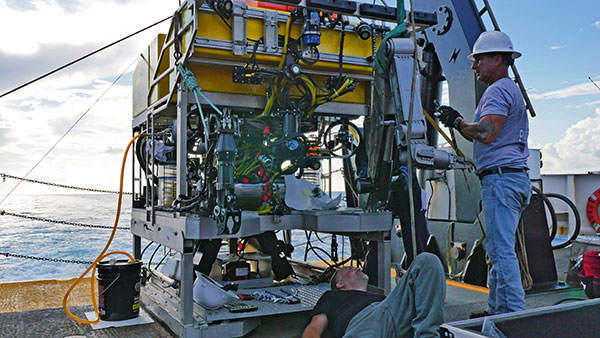
Pelagic Research Services CEO Ed Cassano inspects the redesigned ROV Odysseus, equipped with state-of-the-art tech including a SubC 1Cam Alpha (MK5) HD fiber optic camera.
Credits
Editor: Greg Leatherman
Photography: NOAA, Pelagic Research Services
Creative: Emille Rodriguez, John Paquette