")
Methane is among the most potent greenhouse gasses, and the largest methane reservoir on Earth is stored at continental margins—the underwater region that connects the dry land with the deep ocean. Maritime technology for mapping the ocean floor shows us that methane is constantly being released into the ocean, a natural phenomenon known as methane seepage. A widespread phenomenon that has been occurring for hundreds and even millions of years, methane seepage has a strong connection not only to our global climate but also to deep seabed ecosystems, as well as underwater landslides and tsunamis.
The Arctic Ocean, in particular, leaks enormous amounts of methane. Various studies indicate that leakage intensifies when glacial ice disappears. However, leakage also intensifies on a daily basis. Methane bubbles recorded in sonar data show a cyclic increase and decrease of their intensity according to diurnal tide cycles. We traveled to Svalbard's west coast to study the relationship between tides and methane release in an experiment conducted at below 800 meters depth using a piezometer, an instrument that measures pressure changes inside the sediment. The study observations imply that there may be much more methane leaking from the ocean than what can be predicted with standard seafloor mapping methods. Here we describe the experiment and the fascinating findings.
The Fram Strait: A Natural Geological Laboratory
The continents are constantly moving. While some continents are moving away from each other, other continents are colliding. Every year Norway moves about two centimeters further away from Greenland. As the separation occurs, the newly created seafloor moves away from the high-temperature regions where it was formed, cools down and fractures, and pushes against older material at the continental margin. Continental margins, either covered by glacial ice such as Greenland today or Svalbard some ten thousand years ago, are even more prone to deformation at the present day. These continents are constantly bending back to their original shapes, especially now that the weight of the ice has disappeared (Svalbard) or is currently disappearing (Greenland). This bending also causes cracking of the sediments. All this cracking exerts an important control on the amount of methane released into the ocean. When large ice masses are present, they impinge a lot of pressure on the adjacent ocean floor and keep the methane frozen inside the sediment, forming what is known as gas hydrates. With the melting of the glacial ice and the increasing human-caused warming effect in the Arctic, methane both from hydrates and gaseous accumulations can leak more easily and may accelerate global warming.
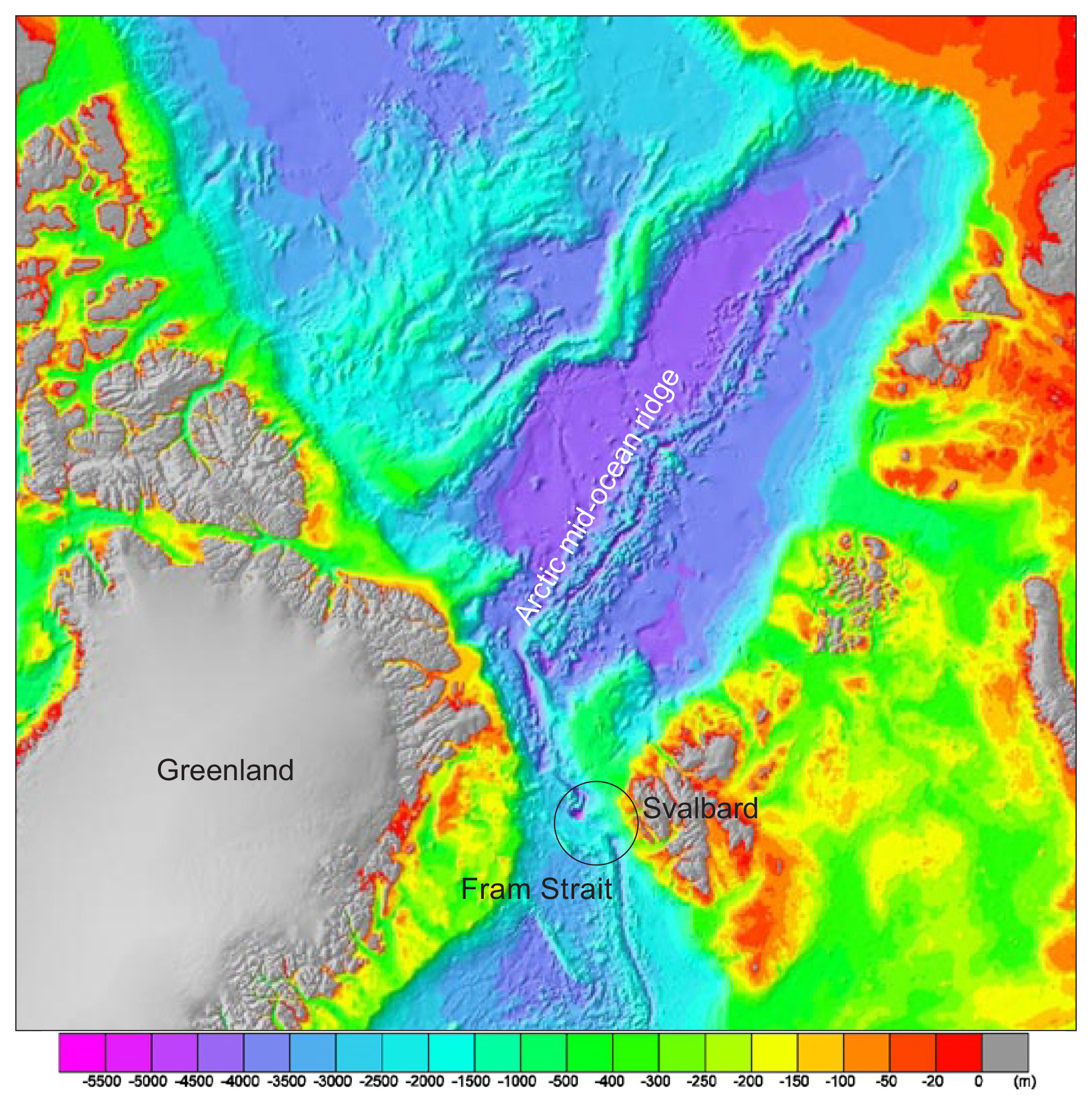
International Bathymetry Chart of the Arctic Ocean showing the study area. (Image credit: Andreia Plaza-Faverola)
Seabed Methane Emissions in the Fram Strait
The Fram Strait is the passage between Greenland and Svalbard. It is the largest and only gateway allowing the exchange of deep waters between the Arctic and the Atlantic Ocean. This region is a natural laboratory for understanding the Earth's ocean currents, global climate, plate tectonics, and studying the methane seepage phenomenon. Leakage of methane in the Fram Strait has been discovered by observing distinct colorful "flares" in sonar data. Every year, vessels of all kinds navigating the eastern Fram Strait report flares systematically located at the same spots along the Svalbard continental margin—at around 80 meters, between 300–400 meters, and about 1,200 meters deep.
(Image credit: The SEAMSTRESS Project)
Moreover, geological, biological, and geophysical data show evidence of past methane leakage at the seafloor where flares are not observed today. This tells us that methane leaks were much more abundant and intense in the past. But what is controlling the where, when, and how much methane leaks? Intrigued by this question, we started a project that, through numerous experiments, aims to solve this mystery.
The Piezometer Experiment Off The Svalbard Coast
In one of the most revealing experiments so far, we measured the pressure and the temperature variations under the seabed using a piezometer designed by Ifremer, the French Institute for Exploration of the Sea. A piezometer is a tubular instrument that can be pushed into the ground to measure the pressure and temperature of the water inside the soil. When used at sea, the tube is open, so the sensors inside it are in contact with both the pressure of the water column (hydrostatic pressure) and the pressure at given depths inside the sediment. If the pressure inside the sediment is the same as the hydrostatic pressure, the instrument tells us that the water in the sea is nicely interconnected with the fluid inside the sediment. If the pressure inside the sediment is lower than the hydrostatic pressure, the instrument tells us that a material with less density than water (i.e., methane gas in this context) is present in the sediment.
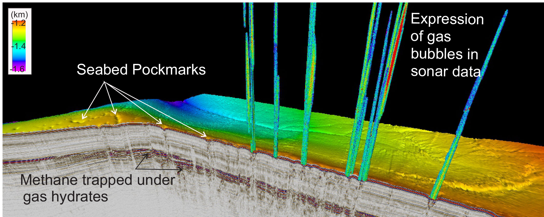
Expression of gas in the sediment and in the water column when it escapes to the ocean. Gas hydrates, the frozen form of the gas in the sediment, forms until a certain depth and more gas accumulated underneath. (Image credit: Andreia Plaza-Faverola)
In 2019, we measured for the first time the pressure inside the sediment in an Arctic region. We carefully chose four locations off the west-Svalbard coast, where we could safely insert the piezometer. We were looking for sediment pressure differences between areas with and without obvious and pronounced methane flares. The Arctic weather made no exception with us, and it became rough enough to impede our sampling plans. But the data collected from two of the sites were unexpectedly contrasting. They revealed a fascinating link between changes in sea level and the pressure inside the sediments.
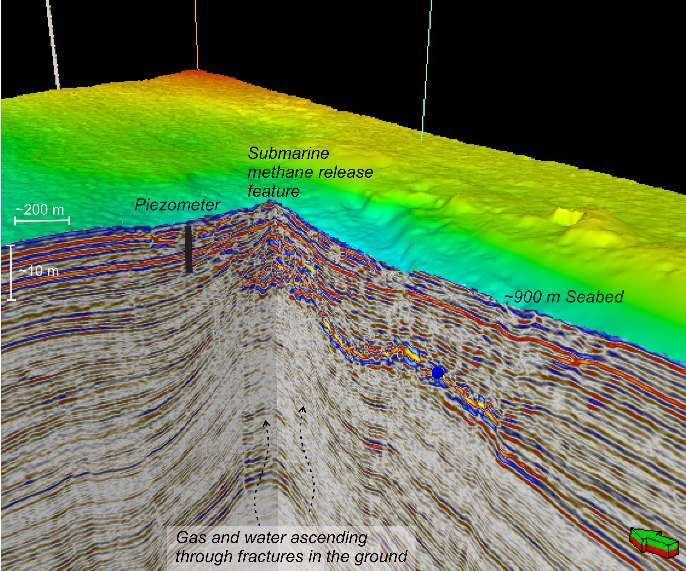
Imaging of a mud-volcano type of submarine methane release feature in bathymetry and seismic data. Negative pressures recorded by the piezometer revealed that there is gas trapped near the seabed that escapes to the ocean in response to tidal pressure changes. (Image credit: Andreia Plaza-Faverola)
We left the piezometers recording the pressure over three days at two distinct locations. It becomes clear that the water inside the sediment was changing rhythmically following the tide cycles at both locations. One of our piezometers unexpectedly hit what we think could be a dormant mud volcano. Mud volcanoes are formed as pressure increases beneath the seafloor, pushing water, gas, and mud towards the seafloor and eventually erupt. The piezometer data showed that at this location, there was not only water in the sediment but also gas moving upward and escaping to the ocean (parallel to) the rhythm of the moon.
Connection Between Tides and Seabed Methane Leaks
Methane is much more vulnerable to changes in pressure than water. The small decrease in the pressure exerted by the water column during low tides was enough to allow the gas to move upward and leak out to the ocean. The negative pressures were not constant, but the pressure would go up and down in cycles of several hours, comparable to diurnal tide cycles.
The resemblance between the pressure log and the tides calculated for the area over the three days of measurements was remarkable. Several of the low-pressure pulses matched the time of low tide and a pulse of warmer temperatures. It revealed that tides were pumping gas from deeper depths, into the seafloor and out into the water. Interestingly, the gas released into the water at this site has not been observed as gas flares in the sonar data. Why's that? We suspect that the short periodicity and low intensity of methane release prevent the leaks from being observed using our regular geophysical tools, which may mean that we have underestimated the amount of gas release all along.
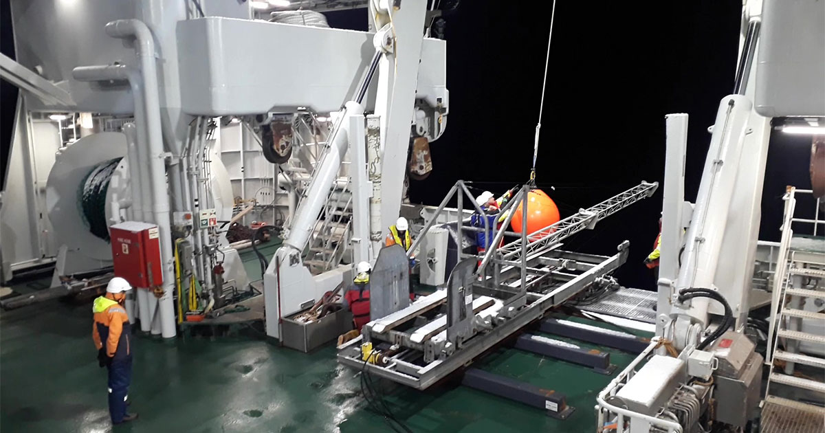
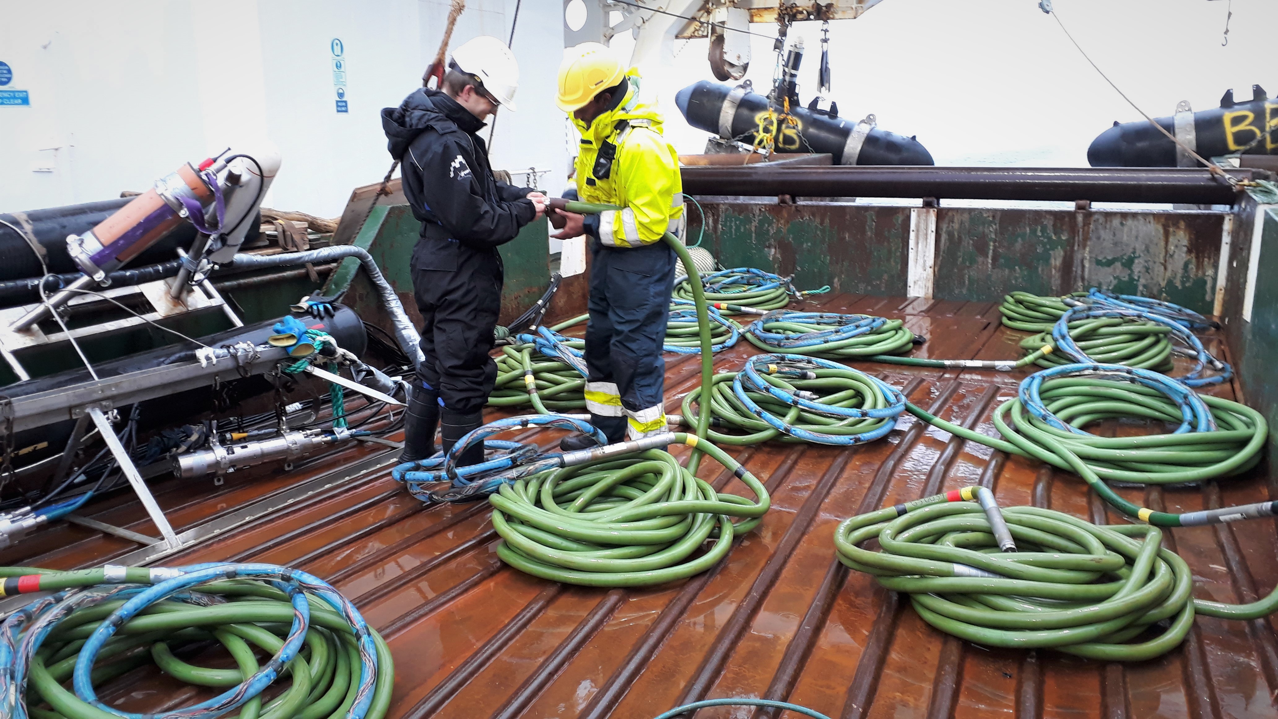
Photograph of the Ifremer Piezometer on the deck of R/V Kronprins Haakon, waiting to go in the water. (Image credit: Jochen Knies)
This first piezometer experiment in the Fram Strait was eye-opening. It demonstrated how seabed methane emissions can be much more spread out and abundant than anticipated by mapping the leaks with geophysical data. What's more, it's clear that the moon and the ocean contribute to the Earth's rhythmic release of gas.
As Earth continues to warm, having a greater understanding of how methane is influenced by the rhythm of the tides becomes more vital. Installing long-term piezometer observatories will help us to better understand and quantify this fascinating connection between the moon, the ocean, and seabed methane emissions.
This feature appeared in Environment, Coastal & Offshore (ECO) Magazine's 2021 Summer edition, to read more access the magazine here.
