")
The record storm surge in October 2023 caused severe damage to the German Baltic coast. Effective adaptation scenarios to rising sea levels are therefore becoming increasingly urgent. In two recent studies, researchers at Kiel University have modeled both the flooding extent along the Baltic Sea coastal areas and, for the first time, two possible upgrades for current dike lines in high resolution.
They modelled various storm surge and sea level rise scenarios. Their results show that, based on the current dike line, neither an increase nor managed realignment, i.e., controlled breaching of seaward defenses and relocation of primary defense line further inland, as a nature-based solution can be sufficient to protect people, infrastructure, or buildings to significantly reduce the risk of flooding along the German Baltic Sea coast by the year 2100. In the model, the risk for the population compared to today's existing coastal protection was only reduced by a maximum of 26% for the scenario of managed realignment. Their results were published on November 24 in the journal Communications Earth & Environment and at the beginning of September in Natural Hazards and Earth System Sciences.
"The majority of our simulated flooding areas are located in Mecklenburg-Western Pomerania, with the hotspots in the lagoons of Fischland-Darß-Zingst, Rügen, Usedom and the Peene estuary. In Schleswig-Holstein, the Flensburg Fjord, Eckernförde Bay, Fehmarn, Travemünde and Lübeck are particularly affected," says first author Dr Joshua Kiesel, postdoctoral researcher in the Coastal Risks and Sea Level Rise working group at the Institute of Geography at Kiel University. Professor Athanasios Vafeidis, co-author of both studies and member of the research priority area Kiel Marine Science (KMS) at Kiel University, leads the working group. "Today, we can still decide for a large part of the German Baltic Sea coast what an adaptation might look like in the future. The known disadvantages of existing dikes should definitely be taken into account,” says Vafeidis. According to the researcher of Kiel University, this is also crucial for protection against future extreme events, which are very likely to become more frequent.
Process-based modelling helps to evaluate adaptation scenarios
Today, nature-based adaptation options are becoming increasingly important. One example of this is managed realignment, which aims to create a natural buffer zone between the sea and the dike. In this buffer zone, coastal wetlands can (re)establish, whose vegetation increases the surface roughness and thus makes a natural contribution to coastal protection. Rare habitats such as salt marshes and reed beds can develop in these buffer zones, which also contribute to the preservation of biodiversity.
Previous models simulate flooding according to the principle of a uniform spread of water when storm surges hit the coast. In the current, process-based modelling, the researchers now also take into account the temporal course of storm surges as well as the attenuation of the surge with its currents and peak water levels when it hits areas of varying roughness, such as wetlands, forests or paved soils. "Compared to previous supra-regional or continental studies, our coastal flooding model is the first to use high-resolution terrain data from state and regional dikes with a resolution of one meter for the entire German Baltic Sea coast. This enabled us to assess the effectiveness of existing and raised dikes on the one hand and of managed realignment on the other. However, based on current defense lines, both will probably not be sufficient to withstand the ongoing sea level rise," says coastal geographer Kiesel.
However, Kiesel and the research team estimate that the protection potential for managed realignment, including raising them, is greater than raising them without realignment. "Managed realignment means that existing dike lines are breached to reestablish regular flooding and sedimentation of low-lying areas. This approach typically involves the construction of a new dike line further inland to protect adjacent people, buildings and infrastructure. There are already several examples of managed realignment along the German Baltic coast," says the scientist. During very high surges, the slightly improved coastal protection function is due to the significantly longer, landward dike line.
In order to identify physically plausible areas for managed realignment, the scientists based their study on several parameters: no direct development behind the dike and no infrastructure in the form of roads or railway networks. In order to compare the effectiveness of dike relocation with conventional coastal protection, all state and regional dikes along the German Baltic Sea coast were also raised by 1.5 meters in accordance with the climate dike concept. "There is a broad scientific debate about managed realignment and nature-based adaptation options in general. However, there has been little research into their effectiveness in terms of coastal protection. Our research fills a gap here. We wanted to know what contribution managed realignment can make to regional coastal protection if it is implemented wherever it is physically possible," says Kiesel. For this reason, socio-economic considerations and the frequent lack of acceptance among the population for such measures, which also involve interventions in the infrastructure, were not taken into account.
Flood maps for the German Baltic Sea coast
In their first study from September 2023, around a month before the severe storm surge, the research team led by Kiesel and Vafeidis had already been able to prove with two high end sea level rise scenarios that the entire German Baltic Sea coast is at high risk of flooding and that upgrades to coastal protection are necessary. To do this, they coupled a model of the western Baltic Sea with a coastal flooding model.
The spatial information on dikes and vegetation usually requires good local knowledge and cooperation with the authorities. "Without our transdisciplinary approach, we would not have been able to provide our flood maps in this resolution," adds co-author Vafeidis, whose working group works closely with the state authorities.
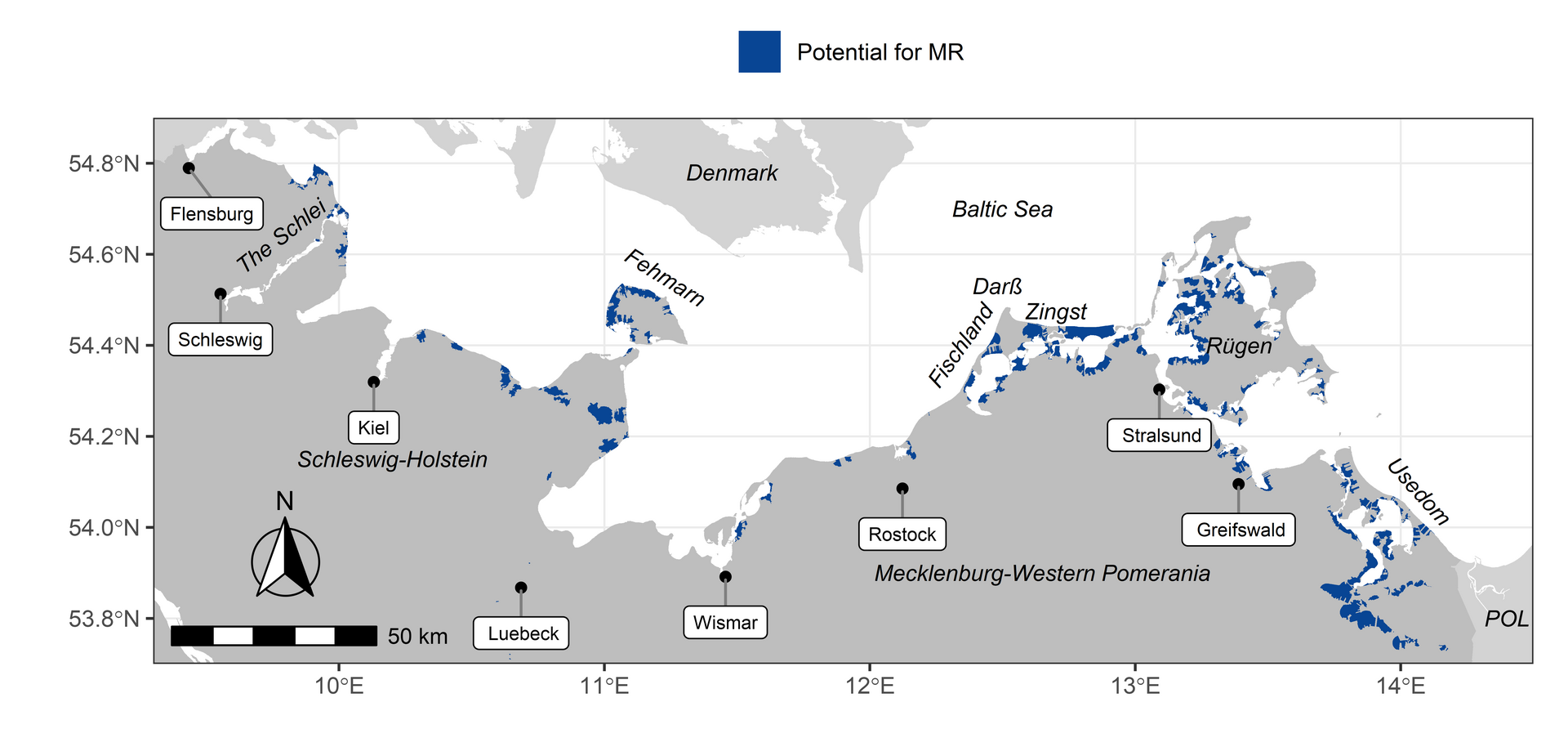 Study area and potential managed realignment sites across the German Baltic Sea coast: The detection of managed realignment sites excludes all areas in which major roads, railways or any kind of development occur and which are higher than ten metres above sea level. (Image credit: Kiesel, J. et al. (2023), Commun Earth Environ)
"Now, not later": More research into adaptation concepts
With the climate dike concept of the state of Schleswig-Holstein and the planned dike constructions along the German Baltic Sea coast, the first coastal protection measures are already underway. Kiesel, who now works as a research assistant at the Free University of Amsterdam, would like to continue working closely together in the future: "We need more research into the effectiveness of nature-based adaptation options. The dramatic events of the Baltic Sea storm surge have shown that we should start today if possible. Successive storm surges in a short period of time could also become more frequent in the future. The infrastructure already weakened by the first storm surge would be much more vulnerable to subsequent events, with even worse consequences for the people on the coast."
Developing new and effective adaptation concepts are a challenge that not only countries and people on the German Baltic coast are facing. Such risks are also increasing in Europe. Vafeidis' working group is researching European solutions in the EU Horizon 2020 project "Coastal Climate Core Services" (CoCliCo).
The research results of the two studies were produced in the project "Ecosystem-supporting Coastal Adaptation Strategies for the German Baltic Sea Coast" (ECAS-Baltic), which is funded by the German Federal Ministry of Education and Research (BMBF). The project was coordinated by the Global Climate Forum (GCF) in Berlin. In addition to Kiel University with its coastal geology and coastal geography, the following institutions were involved in the ECAS-Baltic project: the Ludwig Franzius Institute for Hydraulic, Estuarine and Coastal Engineering, Leibniz University Hannover, the Helmholtz Centre Hereon, the Leibniz Institute for Baltic Sea Research Warnemünde (IOW) and the two universities of Rostock and Greifswald.