")
See the iconic Wexford Coastline, from Hook Head to Carnsore Point, in remarkable detail thanks to a new series of maps that have been developed by INFOMAR. From Rosslare Harbour to Cahore Point, these new high-resolution maps highlight the unique and intricate landscapes that lie beneath the waves.
INFOMAR (Integrated Mapping for the Sustainable Development of Ireland’s Marine Resource) has launched the Blue Scale Map Series; a collection of 18 high-resolution bathymetric maps of Ireland’s coastal waters. Developed by a dedicated team of hydrographers, data processors and cartographers, the maps highlight the topography of the coast in remarkable detail.
In 2006, the INFOMAR program was established and is currently one of the world’s largest and leading seabed mapping programs. Funded by the Department of the Environment, Climate and Communications, INFOMAR is a joint venture by the Geological Survey Ireland and the Marine Institute and aims to map Ireland’s seabed and deliver a comprehensive baseline bathymetry dataset to underpin the future management of Ireland’s marine resource.
Ireland’s coastline is approximately 3,171 km in length and boasts some of the most unique & dynamic marine environments in Europe. The Blue Scale Map Series is the culmination of over a decade of work. Each week, INFOMAR will be releasing a new map of a different section of the Irish coastline.
 (Image credit: The Marine Institute)
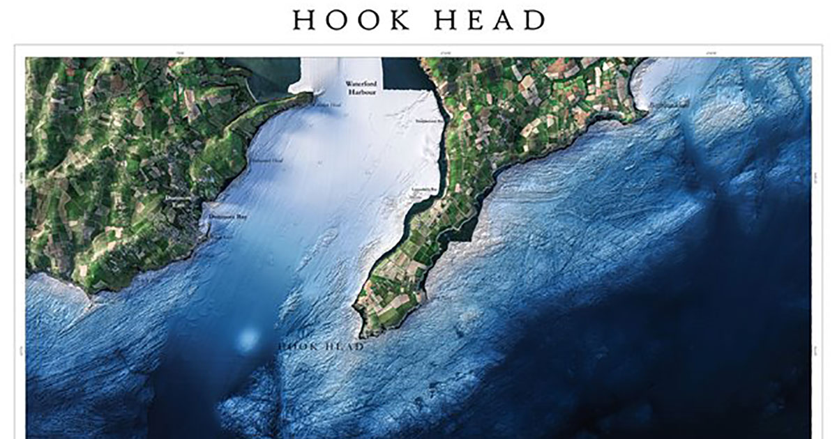
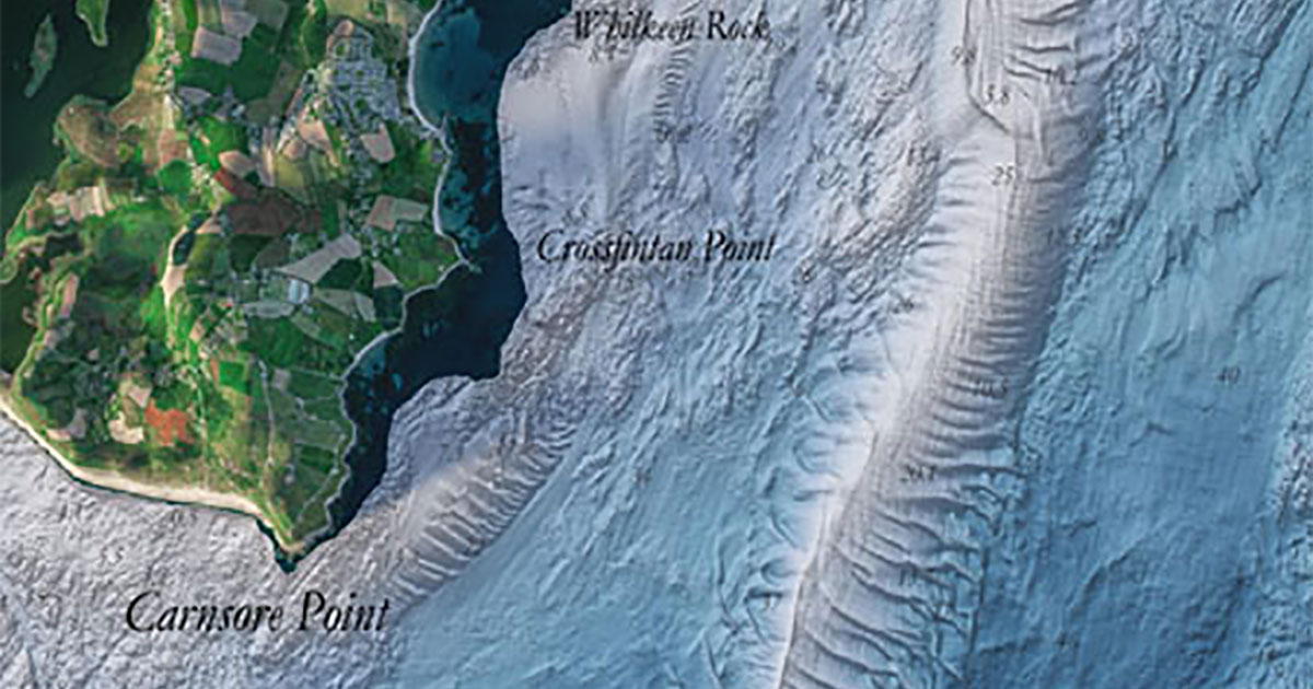
County Wexford has a coastline of approximately 273 km—and showcases some of the Ireland’s most unique coastal landscapes. The latest in the new map series are the Blue Scale bathymetric maps of Hook Head & Carnsore Point. The two maps reveal the brilliant marine geology and unique seafloor across the Wexford Coastline.
The first of the Model County maps is the Bluescale bathymetric map of Hook Head.
Hook Head—historically called Rindowan—is a headland in County Wexford, Ireland, on the east side of the estuary of The Three Sisters (Rivers Nore, Suir and Barrow). It is part of the Hook peninsula and is adjacent to the historic townland of Loftus Hall. This area is the location of Hook Lighthouse, the oldest working lighthouse in the world. Hook Head Lighthouse is one of 70 lighthouses operated by the Commissioners of Irish Lights around the coast of Ireland and plays a vital role in maritime safety.
The Hook Peninsula is composed of many rock types including sedimentary limestone and sandstone. The outcrops around Hook Head consist of abundant exposures of Lower Carboniferous rocks in foreshore platforms, containing beautifully preserved crinoids, bryozoans, bivalves, corals, and brachiopods.
Friday 10th November: Carnsore Point
Carnsore Point is a headland in the southeast corner of County Wexford, Ireland. It marks the southernmost point of the Irish Sea, on the western side of St George's Channel. A large, offshore area wrapped around the Point is a marine protected area (MPA) for its reefs and species-rich underwater life.
The intertidal and offshore reefs are formed of Carnsore granite, a coarse pinkish-brown rock, and range from very exposed to moderately exposed to wave action. In water at depths of 11-30 m there are excellent examples of sea squirt communities. Intricate sandbanks lie due east of the headland and North into the Irish Sea.
 (Image credit: The Marine Institute)
Since 2006, INFOMAR’s seabed mapping efforts have been instrumental in enhancing our understanding of Ireland's underwater landscape.
The Blue Scale Map series offers a new and unique way not only to showcase the mapping effort to date, but also to visualize and communicate complex scientific information to the wider public. As with all INFOMAR data, these high-resolution maps are available for free to download and have huge potential to communicate with local coastal communities and raise awareness on the importance of maintaining the health & integrity of our marine environment.
INFOMAR is making all 18 maps available for free to the public to download in high resolution JPEG format. Follow the journey each week as a new map is released on the INFOMAR website, and join the conversation on Twitter, Instagram & Facebook.
Blue Scale Series release dates:
Friday 11th August: Galway Bay (Galway)
Friday 18th August: Loop Head (Clare)
Friday 25th August: Tralee Bay (Kerry)
Friday 1st September: Iveragh Peninsula (Kerry)
Friday 8th September: Dingle Peninsula (Kerry)
Friday 15th September: Bantry Bay (Cork)
Friday 22nd September: Mizen Head (Cork)
Friday 29th September: Roaringwater Bay (Cork)
Friday 6th October: Seven Heads (Cork)
Friday 13th October: Cork Harbour (Cork)
Friday 20th October: Youghal Bay (Cork/Waterford)
Friday 27th October: Tramore Bay (Waterford)
Friday 3rd November: Hook Head (Wexford)
Friday 10th November: Carnsore Point (Wexford)
Friday 17th November: Wicklow Head (Wicklow)
Friday 24th November: Dublin Bay (Dublin)
Friday 1st December: Donegal Bay (Donegal)
Friday 8th December: Aran Islands (Galway)