")
As the world warms and ice sheets melt, the ocean continually rises. The greater Boston area can expect to see between one and six feet of sea level rise by 2100, according to recent estimates.
To find out what this rise might mean for freshwater supplies, a team of hydrogeologists from the University of Massachusetts Amherst, led by David Boutt, professor of Earth, geographic and climate sciences, partnered with the Southeastern Massachusetts Pine Barrens Alliance (SEMPBA) and 13 other grassroots environmental organizations to develop an innovative new model that can not only predict saltwater intrusion over the next 75 years, but also pinpoint the main sources of salt contamination today—road salt and human development. The team released the results of their study in the recent report, Saltwater Intrusion Vulnerability Assessment in Plymouth, MA.
"For many years now, I've been working with citizen stakeholders in the southeastern corner of Massachusetts," says Boutt, "and in 2021, the Pine Barrens Alliance, an environmental group interested in preserving the area's unique environmental character, approached me with an idea for a project to help assess how communities along the coast could best prepare for climate change."
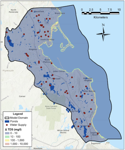 Concentration of total dissolved solids increase from 2020–2100 showing the landward migration of the salt/freshwater mixing zone. (Image credit: UMass)
Boutt and his colleagues, including recent UMass graduate and research assistant Alexander Kirshen, undergraduates Rachel King and Carly Lombardo, graduate student Daniel Corkran and postdoctoral researcher Brendan Moran, jumped at the opportunity to apply their academic research to an urgent, real-world problem close to home.
Plymouth sits on top of a freshwater aquifer—the town's sole source of water. Because Plymouth extends to the ocean's edge, it is extremely susceptible to rising sea levels. For their study, Boutt, Kirshen and colleagues peeked underground to see what was happening.
Groundwater, flowing beneath the surface of the land, and the ocean's water, which, likewise, flows subterraneanly, push against each other and reach an equilibrium state. A well sunk on the freshwater side will flow with sweet water, but one that drills down into the brackish meeting point between fresh and salt will come up briny. As the oceans rise, that sub-surface saltwater pushes farther inland, and wells that have delivered pure water for generations can suddenly turn salty.
While the theory might seem intuitive enough, actually mapping, to say nothing of predicting, the flows and interactions of both fresh and salt water is an enormously complex task.
To start, the team built a salinity database that gathered all the available data from groundwater wells and surface water, such as ponds and streams, in the Plymouth area and measured them for salinity. This gave them a baseline understanding of the current locations and likely sources of elevated water salinity.
Next, Boutt and Kirshen adopted an existing US Geological Survey hydrogeological model, which only focused on the onshore half of the hydrogeology equation, by extending its reach five kilometers offshore. The model includes ponds, streams, terrestrial recharge—or the rate and amount of precipitation that seeps down into the aquifer—as well the various wells that draw from the aquifer and the wastewater that is returned to the aquifer via re-infiltration or septic systems.
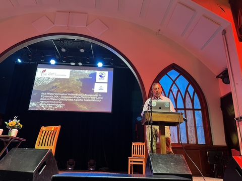 David Boutt presenting the final report to an audience in the Spire Center for Performing Arts in Plymouth, MA. (Image credit: UMass)
Finally, they conducted a series of model runs that took into consideration various scenarios in terms of future precipitation, sea-level rise, groundwater usage and changes in water returned to the aquifer.
"We found that, under the high sea-level rise scenario, areas of the aquifer will increase in salinity by up to 17,000 milligrams per liter by 2100," says Kirshen, "and the mixing zone between the ocean and freshwater will migrate inland by up to 200 meters." While a few ponds might see significant rise in water elevation, by up to 1.8 meters, most ponds would not see their salinity increase from this source of salinization.
The team also learned that water returned to the aquifer by septic systems plays a major role in helping to limit saltwater intrusion. "About 66% of the water that gets pumped out of the aquifer ends up returning to it," says Kirshen.
Perhaps the biggest surprise is that the highest levels of salinity today aren't near the coast, but inland, and especially around the roads. "This surprised me," says Boutt, "and it looks like road salt is one of the main sources of elevated salinity today."
"In partnering with UMass Amherst, we were always thinking beyond the municipal boundaries of Plymouth," says SEMPBA Vice President Frank Mand. "We share an aquifer and a geological foundation with over 30 communities in our ecoregion. So, though the news for Plymouth is good, more importantly we now have a scientific foundation—and new methods for evaluating susceptibility to saltwater intrusion—that are transferrable to those other communities and will help inform Plymouth's and other communities' planning for years to come."
"We were not looking to science to help us recover from our mistakes," Mand adds. "We were seeking to avoid problems in the future. That, in and of itself, was a worthy goal."
To prepare for the future, Boutt and Kirshen recommend further, finer-grained analyses of the region's hydrogeography, the creation of an early warning system to monitor the sites most vulnerable to saltwater intrusion, developing new wells in areas that are at the least risk of salt contamination and reconsidering practices, such as salting the roads in the winter, which are currently responsible for the majority of saltwater contamination in the area.